Nizam Sagar Dam was designed to hold 29.72 TMC of water — but by the time engineers conducted a proper hydrological survey in 1972, barely 40 years after construction, they found its actual capacity had collapsed to just 11.79 TMC. Losing roughly 60% of its intended storage capacity within four decades makes Nizam Sagar one of the most dramatic siltation stories among India’s older dams, and a sobering case study in how quickly an ageing reservoir can lose the very function it was built for.
Nizam Sagar Dam: Overview
| Parameter | Details |
| State | Telangana |
| District | Kamareddy |
| Location | Between Achampet and Banjepally villages |
| Nearest city | Banswada |
| Distance from Hyderabad | Approx. 144 km northwest |
| River | Manjira River, a tributary of the Godavari |
| Dam type | Earthen and masonry |
| Built by | Mir Osman Ali Khan, 7th Nizam of Hyderabad State |
| Construction period | 1923 to 1931 |
| Villages displaced | Over 40 |
| Height | 95.72 metres (314 ft) |
| Length | Approx. 3 km (1.9 mi) |
| Spillway | 3 radial gates |
| Original design capacity | 29.72 TMC ft |
| Capacity per 1972 survey | Just 11.79 TMC ft — a loss of roughly 60% |
| Original irrigation target | 275,000 acres |
| Current irrigation coverage | Over 231,339 acres |
| Canals | Mahabubnagar (Right) Canal, Fatehnagar (Left) Canal |
| Status | Oldest dam in Telangana state |
| Predecessor scheme | Ghanpur Anicut, 1904 |
| Best time to visit | October to February |
The Manjira River and a Modest 1904 Predecessor
Nizam Sagar Dam sits across the Manjira River, a significant tributary of the Godavari whose basin spans a substantial 21,694 sq. km across parts of Maharashtra, Karnataka, and Telangana. Before this dam existed, the Manjira’s water went largely unharnessed on any significant scale.
The first attempt to bring order to this came in 1904, with the construction of the Ghanpur Anicut at a cost of Rs 18 lakh — a much smaller diversion structure than Nizam Sagar would later become. A few points about this earlier scheme:
- Ghanpur Anicut irrigated only around 5,000 acres, a modest achievement compared to what would follow
- It also fed an open channel known as the Mahaboob Nagar (Right Canal) in what was then Medak district
- This earlier project demonstrated the Manjira’s irrigation potential clearly enough to justify a far more ambitious follow-up project less than two decades later
History: A Nizam’s Answer to Recurring Drought
Nizam Sagar Dam was constructed under the direct initiative of Mir Osman Ali Khan, the 7th and last Nizam of Hyderabad State, with the project specifically headed by Nawab Ali Nawaz Jung Bahadur to mitigate the recurring effects of drought across Hyderabad State. Construction ran from 1923 to 1931, an eight-year undertaking that required emptying more than 40 villages to make way for the reservoir.
A few historical points worth noting:
- This makes Nizam Sagar the oldest dam still operating in present-day Telangana, predating India’s independence by well over a decade and reflecting the substantial water infrastructure ambitions of the princely Hyderabad State
- The project was originally conceived to utilise 58 TMC of Manjira water, targeting irrigation across 275,000 acres in the Banswada, Bodhan, Nizamabad, and Armoor taluks of what was then Nizamabad district
- Its completion in 1931 made it, at the time, the largest irrigation scheme yet undertaken within Hyderabad State, a genuinely significant achievement of princely-era engineering
Engineering Specifications
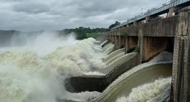
Nizam Sagar Dam is built as a combined earthen and masonry structure, standing 95.72 metres (314 ft) tall and stretching approximately 3 km in length, with a masonry width of roughly 14 ft at certain sections.
Core specifications:
- Height: 95.72 metres (314 ft)
- Length: approximately 3 km (1.9 mi)
- Spillway: 3 radial gates
- Maximum estimated flood flow capacity: 5,25,000 cusecs
- Original design storage capacity: 29.72 TMC ft
This scale placed Nizam Sagar among the more ambitious irrigation engineering projects undertaken anywhere in India during the 1920s, reflecting genuine technical sophistication for its era.
The Silting Crisis: When a Reservoir Loses Most of Its Capacity
The most striking chapter in Nizam Sagar’s operational history isn’t its construction but its subsequent decline. A hydrological survey conducted in 1972 — just over four decades after the dam’s completion — revealed that the reservoir’s actual effective capacity had dropped to a mere 11.79 TMC ft, down from its original design capacity of 29.72 TMC ft.
This represents a loss of roughly 60% of the dam’s intended storage capacity, a far more severe decline than typically documented at comparable Indian dams of similar age. A few points about this crisis and its response:
- Such dramatic siltation reflects decades of accumulated sediment inflow from the Manjira’s catchment, a common but rarely this severe challenge for ageing Indian reservoirs
- In response, modernisation projects were undertaken during the 1970s specifically to raise the dam’s full reservoir level, an engineering intervention aimed at partially compensating for the lost storage volume
- Despite these efforts, the underlying siltation problem reflects a structural, ongoing challenge rather than a one-time fix, and continues to shape how much water the dam can reliably provide during any given irrigation season
For anyone researching Nizam Sagar’s practical reliability today, this capacity loss is arguably more consequential to understanding the dam’s current performance than its original 1931 design specifications.
What the Dam Still Irrigates Today
Despite its severe siltation challenges, Nizam Sagar continues functioning as a significant irrigation source for the surrounding region, now supporting over 231,339 acres through two main canal systems:
- Mahabubnagar Canal (Right Canal)
- Fatehnagar Canal (Left Canal)
These canals serve numerous mandals across the region, including Nizamsagar, Kotgir, Yedpally, Makloor, Jakranpally, Banswada, Varni, Nizamabad, Penjal, Velpoor, Birkoor, Bodhan, Dichpally, Nandipet, and Balkonda. The project’s continued operation, even at reduced capacity relative to its original design, underscores how central this nearly century-old structure remains to agricultural water security across Nizamabad and Kamareddy districts.
Notably, Nizam Sagar’s ongoing water supply is also supplemented by surplus Manjira water managed at Singur Dam, a later structure built further upstream between 1979 and 1998, reflecting how the broader Manjira basin has been developed as a coordinated, multi-decade water management system rather than a single isolated project.
A Note on the Manjira’s Interstate Dimension
Given that the Manjira-Godavari basin spans Maharashtra, Karnataka, and Telangana, water management along this system carries an interstate dimension similar in principle to other shared river basins profiled elsewhere. While detailed specifics of any formal interstate dispute involving Nizam Sagar specifically aren’t extensively documented in the sources reviewed here, the basin’s multi-state catchment means that upstream water use decisions in neighbouring states can, in principle, affect flow reaching Telangana’s reservoirs on the Manjira, a dynamic worth being aware of for anyone following the region’s water security more closely.
Planning a Visit to Nizam Sagar Dam
For anyone considering a trip:
- Getting there: The dam sits between Achampet and Banjepally villages in Kamareddy district, roughly 144 km northwest of Hyderabad, with Banswada as the nearest city
- Best season: October through February offers the most comfortable weather and typically the fullest reservoir following the monsoon
- Historical interest: As the oldest dam in Telangana, visitors interested in the state’s pre-independence engineering heritage will find genuine historical value in the site, distinct from its current, siltation-affected operational capacity
- What to expect: A historically significant but functionally strained reservoir, reflecting both the ambition of its 1920s construction and the very real challenges of maintaining century-old water infrastructure
FAQs
Q1. Why did Nizam Sagar Dam lose so much of its storage capacity compared to other Indian dams of similar age?
While all reservoirs experience some siltation over time, Nizam Sagar’s 1972 survey revealed an unusually severe capacity loss of roughly 60%, reflecting decades of sediment accumulation from its catchment that proved more significant than typically documented at comparable dams, prompting the 1970s modernisation efforts to help compensate.
Q2. Is Nizam Sagar Dam still able to reliably irrigate the farmland it was originally designed for?
It continues irrigating a substantial area, over 231,339 acres, but this is less than its original 275,000-acre design target, reflecting the ongoing impact of its reduced storage capacity on the dam’s full irrigation potential.
Q3. Why is Nizam Sagar Dam named after a person rather than a river or place, unlike most Indian dams?
It was constructed under the direct initiative of Mir Osman Ali Khan, the 7th Nizam of Hyderabad State, and named in his honour, reflecting a common naming convention for major infrastructure projects commissioned by princely rulers during this pre-independence era.
Q4. Does the Manjira River’s status as an interstate river affect how much water reaches Nizam Sagar Dam?
Since the Manjira-Godavari basin spans Maharashtra, Karnataka, and Telangana, upstream water use in neighbouring states can, in principle, influence flow reaching Telangana’s reservoirs, though Nizam Sagar’s more immediate operational challenge has historically been its own severe siltation rather than documented interstate allocation disputes.