Blog

  • Banasura Sagar Dam Wayanad: History, Location, River, Length, State

    Banasura Sagar Dam Wayanad: History, Location, River, Length, State

    Perched at an altitude of nearly 775 metres in the misty hills of Wayanad, the Banasura Sagar Dam holds a rare distinction — it is the largest earthen dam in India and the second largest of its kind in all of Asia. Built across the Karamanthodu, a tributary of the Kabini river, this dam doesn’t just store water for a drought-prone region; it has quietly become one of Kerala’s most photographed landscapes, with jade-green islands rising out of the reservoir like something from a painting.
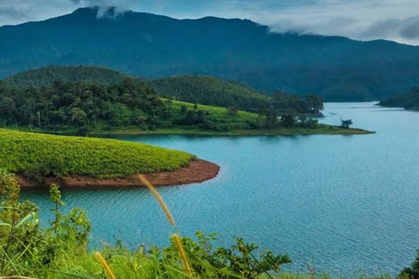
    Banasura Sagar Dam Wayanad

    Quick Facts: Banasura Sagar Dam

    Detail

    Information

    Official name

    Padinjarathara Dam (Kuttiyadi Augmentation Main Earthen Dam)

    Popular name

    Banasura Sagar Dam

    State

    Kerala

    District

    Wayanad

    Nearest town

    Padinjarathara, near Kalpetta

    River

    Karamanthodu (tributary of the Kabini/Kabani river)

    River basin

    Kabani basin

    Dam type

    Homogeneous rolled earth-fill dam

    Height (from foundation)

    38.5 metres (126 ft)

    Length

    685 metres (approx. 2,247 ft)

    Full Reservoir Level (FRL)

    EL 775.60 m

    Storage capacity

    209.25 million cubic metres (169,642 acre-ft)

    Water spread area

    12.77 sq. km

    Catchment area

    61.44 sq. km

    Installed power capacity

    231.75 MW

    Number of saddle dams

    6

    Year commissioned

    2005 (construction began 1979)

    Owner/operator

    Kerala State Electricity Board (KSEB)

    Rank in India

    Largest earthen dam

    Rank in Asia

    Second largest earthen dam

    Best visiting months

    October to May

    Nearest city

    Kalpetta (approx. 21 km)

    Where the Dam Gets Its Name

    The dam is named after Banasura, the thousand-armed Asura king said to be the son of Mahabali and grandson of Prahlada in Hindu mythology. Local legend holds that the surrounding hills — the second-tallest range in Wayanad — were once his stronghold. This mythological connection is more than folklore; it shapes how the dam is marketed and experienced by visitors, many of whom arrive specifically because of the story behind the name rather than the engineering itself.

    The River Behind the Reservoir

    Banasura Sagar Dam does not sit on a major river in the way most large Indian dams do. Instead, it impounds the Karamanthodu, a relatively modest hill stream that itself feeds into the Kabini (also spelled Kabani), which eventually merges with the Cauvery system further downstream. This matters for a simple reason: the dam was never designed to tame a massive river’s flow. It was built to trap monsoon runoff from a compact catchment of about 61 sq. km, store it at height, and release it in a controlled way through a canal network.

    That distinction explains the dam’s engineering design. Rather than a single concrete gravity structure, the project relies on:

    • One main earthen dam at Padinjarathara
    • A concrete gravity spillway dam alongside it
    • Six saddle dams (Kosani, Kuttiyadi, Nayamoola, Manjoora, and two near Kottagiri) that plug lower ridge points around the reservoir rim

    Together, these structures seal off the entire basin so the reservoir can hold its full 209 million cubic metres without water escaping through natural gaps in the surrounding hills.

    Why It Was Built: The Kuttiyadi Augmentation Scheme

    Work on the Banasurasagar Project began in 1979 as part of the larger Kuttiyadi Augmentation Scheme, a plan devised to solve two connected problems facing this part of Kerala:

    • Seasonal water scarcity — Wayanad and neighbouring areas faced acute shortages of irrigation and drinking water during dry months, despite heavy monsoon rainfall.
    • Power generation shortfall — The existing Kakkayam hydroelectric project needed a steadier water supply to operate at capacity.

    By damming the Karamanthodu at height and channelling water through a canal system, engineers created a reservoir that could feed the Kakkayam power project year-round while also releasing water for irrigation downstream. The dam became fully operational in the mid-2000s, decades after the scheme was first conceived — a timeline typical of large multipurpose water projects in hilly terrain, where saddle dam construction and land acquisition slow progress considerably.

    Engineering Scale: What Makes It “Largest”

    The “largest earthen dam” title isn’t about height — at 38.5 metres, Banasura Sagar is modest compared to concrete dams elsewhere in India. The scale claim rests on a different measure: the sheer volume of earth, stone, and rubble packed into the structure to hold back water across a wide hill gap.

    Key figures that support this ranking:

    • Length of roughly 685 metres along the main earthen embankment
    • A full reservoir level held at an elevation of 775.60 metres
    • Storage capacity exceeding 209 million cubic metres of water
    • A water spread area of nearly 13 sq. km once the reservoir is full

    This combination of length, height, and storage volume, achieved without a single continuous concrete wall, is what places it ahead of every other earthen dam built in the country.

    A Reservoir That Became a Tourist Landmark

    Few Indian dams double as scenic attractions the way this one does. When the reservoir filled, it submerged low-lying land around the original riverbed, leaving behind a scattering of hillocks that now sit as green islands surrounded by water on all sides. Boat rides across the reservoir, walking trails along the dam’s crest, and viewpoints overlooking the Banasura hills have turned what was originally a pure irrigation and power project into one of northern Kerala’s most visited sites, drawing well over a lakh of visitors annually.

    Points worth knowing before planning a visit:

    • The dam is roughly 21 km from Kalpetta town, the usual base for Wayanad travel
    • Entry is regulated by KSEB, and boating is typically managed through a separate ticketing counter
    • Visibility and water levels are best just after the monsoon, from October onward
    • Photography from the top of the dam offers clear views of the reservoir islands and surrounding hill ranges

    Environmental and Regional Significance

    Beyond tourism, the dam continues to serve its original purpose. It stabilises water availability for irrigation in a district that depends heavily on agriculture, and it supports hydroelectric generation with an installed capacity of 231.75 MW. In recent years, the reservoir has also hosted one of India’s early floating solar power installations, adding a renewable energy layer to a site already generating hydroelectricity — a detail that positions Banasura Sagar as more than a legacy infrastructure project, but as a site still being adapted for newer energy needs.

    FAQs

    Is Banasura Sagar Dam the same as Banasura Hill?

    No. Banasura Hill is the second-tallest peak in Wayanad and forms the scenic backdrop to the dam; the dam itself is a separate earthen structure built at its base.

    Can visitors walk across the dam?

    Yes, a section of the dam’s crest is open to visitors, offering views over the reservoir islands, though access points and timings are set by KSEB and can vary seasonally.

    Why is it called an earthen dam instead of a concrete dam?

    It is built primarily from compacted earth, stone, and rubble rather than poured concrete, which is why its “largest” ranking is based on the volume of material used rather than height alone.

    Does the dam affect a major river system?

    Not directly. It dams the Karamanthodu, a tributary stream, though its downstream effects eventually connect to the wider Kabini river network.
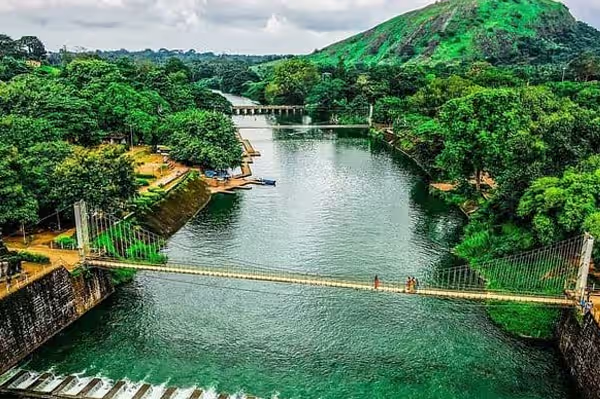
  • Malampuzha Dam Kerala: History, Location, River, Length, State

    Malampuzha Dam Kerala: History, Location, River, Length, State

    Kerala’s largest reservoir isn’t hidden away in some remote forest belt — it sits just eight kilometres from Palakkad town, easily reachable, yet few visitors realise the numbers behind what they’re looking at. Malampuzha Dam holds back 226 million cubic metres of water across a catchment stretching nearly 148 square kilometres, making it the single biggest water-storage structure anywhere in the state. Built in the years right after Independence, it remains one of Kerala’s earliest and most ambitious irrigation projects.

    Malampuzha Dam Kerala

    Quick Facts about Malampuzha Dam Kerala

    Parameter

    Details

    State

    Kerala

    District

    Palakkad

    Nearest town

    Palakkad city (approx. 8 km)

    River

    Malampuzha river (tributary of Bharathapuzha)

    River basin

    Bharathapuzha basin

    Dam type

    Composite — masonry dam + earthen dam

    Masonry section length

    1,849 m

    Earthen section length

    220 m

    Total length

    Approx. 2,069 m

    Height

    115 m (approx. 377 ft)

    Reservoir capacity

    226 million cubic metres (8 tmc ft)

    Catchment area

    147.63 sq. km

    Command area served

    Approx. 42,090 hectares

    Construction started

    27 March 1949

    Inaugurated

    9 October 1955

    Built by

    Public Works Department, Madras State (pre-reorganisation)

    Current operator

    Kerala Water Resources Department

    Rank in Kerala

    Largest dam and reservoir in the state

    Best time to visit

    November to February

    A Project That Predates Kerala Itself

    Here’s something most visitors don’t know: Malampuzha Dam wasn’t originally a Kerala project at all. When the foundation stone was laid on 27 March 1949 by M. Bhaktavatsalam, then Public Works Minister, this entire region fell under Madras State — Kerala as a state didn’t exist until the reorganisation of 1956. Construction ran for roughly six years, and the dam was formally opened on 9 October 1955 by K. Kamaraj, then Chief Minister of Madras. Only after the States Reorganisation Act redrew the map did Malampuzha become a Kerala asset, inheriting a project built for an entirely different administrative purpose.

    The motivation behind building it had nothing to do with tourism or landscaping — that came decades later. Palakkad’s plains needed a reliable water source for paddy cultivation, and the seasonal flow of local rivers simply wasn’t dependable enough on its own.

    The River That Feeds It

    The dam takes its name directly from the river it dams — the Malampuzha, a tributary that eventually joins the Bharathapuzha, Kerala’s second-longest river after the Periyar. Unlike dams built on major perennial rivers, Malampuzha’s water source depends heavily on the monsoon catchment across the surrounding hill ranges of the Western Ghats. That catchment — spread across 147.63 sq. km — funnels rainfall runoff directly into the reservoir, which then holds it back for controlled release through the year.

    This dependence on monsoon-fed catchment rather than a large river system explains a few practical realities:

    • Reservoir levels fluctuate noticeably between pre-monsoon and post-monsoon months
    • The dam’s irrigation output is closely tied to how strong the southwest monsoon performs each year
    • Water release is managed through two separate canal systems rather than a single outlet

    How the Dam Is Actually Built

    Malampuzha isn’t one continuous structure — and this is where a lot of published figures get confusing. It’s a composite dam made of two connected sections:

    • A masonry dam section running 1,849 metres
    • An earthen dam section adding another 220 metres

    Combined, this gives the dam a total length of about 2,069 metres, making it the longest dam in Kerala by that measure. Its height is recorded at 115 metres, a figure substantial enough that Malampuzha ranks among the taller dam structures in South India, even though it isn’t the tallest overall.

    The reason for mixing masonry and earthen construction comes down to terrain. Where the riverbed and foundation rock could support a rigid masonry structure, engineers built it that way for durability; where the ground favoured a sloped, compacted design, the earthen section took over. This hybrid approach was common in mid-20th-century Indian dam engineering, before large-scale concrete gravity dams became the default choice.

    From Irrigation Project to Kerala’s Garden City

    What sets Malampuzha apart from most Indian dams built for pure irrigation is what grew up around it afterward. The reservoir’s surrounding land was developed into the Malampuzha Garden, now one of the most-visited recreational spots in Palakkad district, drawing families, school trips, and tourists from across the state.

    Key attractions that have grown around the dam site over the decades include:

    • A large ornamental garden complex with fountains and topiary work
    • A rock garden inspired by Chandigarh’s famous rock garden design
    • A cable car ride offering aerial views of the reservoir
    • Boating facilities on the reservoir itself
    • A children’s park and an aquarium built within the same complex

    This transformation matters for anyone planning a visit: Malampuzha today functions less like a typical restricted-access reservoir and more like an integrated tourism destination, with the dam itself as just one part of a much larger day-trip experience.

    Why the Dam Still Matters to Palakkad

    Ornamental gardens aside, Malampuzha’s core job hasn’t changed since 1955. It remains the primary irrigation source for a command area of roughly 42,090 hectares across Palakkad district, an area often called the “rice bowl of Kerala” precisely because of assured water supply from projects like this one. Two canal systems distribute water from the reservoir to farmland across the plains, supporting paddy cultivation that would otherwise depend entirely on monsoon timing.

    A few points worth keeping in mind about its ongoing role:

    • The dam supplies both irrigation water and, to a lesser extent, drinking water to nearby settlements
    • Its storage capacity of 226 million cubic metres makes it a critical buffer during weak monsoon years
    • Water release schedules are coordinated with the district’s agricultural calendar, particularly during the paddy-growing seasons

    Planning a Visit

    Malampuzha’s easy access from Palakkad city — under half an hour by road — makes it a practical half-day or full-day trip rather than a remote expedition. A few practical notes:

    • The garden and dam complex typically stay open through daylight hours, with separate ticketing for the garden, boating, and cable car
    • Weekday visits tend to be far less crowded than weekends and school holidays
    • Post-monsoon months (November through February) offer the fullest reservoir and greenest surrounding landscape
    • Combining a Malampuzha visit with other Palakkad attractions like Palakkad Fort works well for a single-day itinerary

    FAQs

    Is Malampuzha Dam the tallest dam in Kerala?

    No, it isn’t the tallest, but at roughly 2,069 metres it is the longest dam in the state, and its reservoir has the largest storage capacity of any dam in Kerala.

    Can visitors actually walk on the dam itself, or is it only the garden that’s open?

    Both are accessible — visitors can view the dam structure and reservoir, while the adjoining garden, rock garden, and cable car are separately ticketed attractions within the same complex.

    Why does the dam have two different construction types in one structure?

    Engineers used masonry where the foundation rock could support a rigid structure and switched to earthen construction where the terrain suited a compacted embankment instead, a common hybrid approach in dams of that era.

    Does Malampuzha Dam supply drinking water, or is it only for irrigation?

    Its primary purpose is irrigation for roughly 42,090 hectares of farmland in Palakkad district, though it also contributes to drinking water supply for parts of the surrounding area.