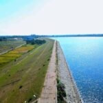
When Jawaharlal Nehru personally inaugurated Tilaiya Dam on 21 February 1953, he wasn’t just opening a single reservoir — he was marking the completion of independent India’s first-ever multipurpose river valley project, built on a vision an American Tennessee Valley Authority engineer had drawn up specifically for the flood-ravaged Damodar basin. Decades later, the neighbouring town of Jhumri Telaiya would go on to earn its own peculiar fame, becoming the single largest source of song requests mailed to All India Radio in the pre-television era.

Tilaiya Dam: Overview
| Parameter | Details |
| State | Jharkhand |
| District | Koderma |
| Location | Tilaiya, on the Koderma-Hazaribagh road |
| Distance from Koderma headquarters | Approx. 22.3 km |
| River | Barakar River |
| Dam type | Concrete gravity dam |
| Height | 30.28 metres (99.3 ft) |
| Length | 366 metres (1,201 ft) |
| Spillway | Concrete, discharge capacity 1,348 cubic metres/second |
| Inaugurated | 21 February 1953, by PM Jawaharlal Nehru |
| Owner/operator | Damodar Valley Corporation (DVC) |
| Reservoir total capacity | 380.71 million cubic metres (13.45 TMC ft) |
| Reservoir surface area | Approx. 59.08 sq. km |
| Installed power capacity | 4 MW (2 x 2 MW) |
| Historical significance | First of DVC’s four dams; India’s first completed multipurpose river valley project |
| Design consultant | W. L. Voorduin, senior engineer of the American Tennessee Valley Authority |
| Original plan | 8 dams proposed; only 4 were ultimately built |
| Notable wildlife | Deer and gharial reportedly seen on reservoir islands |
| Nearby cultural landmark | Jhumri Telaiya, famous for All India Radio song requests |
| Best time to visit | October to February |
The Barakar River and a Flood That Changed Everything
Tilaiya Dam is built across the Barakar River, a major tributary of the Damodar River, in Koderma district. Its very existence traces back to a specific catastrophe: the devastating Damodar valley flood of 1943, which prompted the government of Bengal to establish a high-powered body called the Damodar Flood Enquiry Committee to investigate solutions.
A few points about this river’s broader significance:
- The Barakar hosts two of the four DVC first-phase dams — Tilaiya and Maithon — reflecting the river’s central role in the broader Damodar Valley Project
- The 1943 flood’s severity was significant enough to prompt genuinely radical policy thinking, with the committee ultimately recommending India establish a body modelled directly on an American institution rather than pursuing incremental, piecemeal flood-control measures
History: An American TVA Engineer’s Vision for Eight Dams
The Damodar Flood Enquiry Committee’s recommendation led to something genuinely unusual for pre-independence India: the direct recruitment of an American engineer to study and redesign the entire river basin’s water management. W. L. Voorduin, a senior engineer with the Tennessee Valley Authority in the United States, was specifically appointed to study the Damodar’s flooding problem.
Voorduin’s 1945 preliminary memorandum proposed a unified development plan for the entire basin — and his original vision was considerably more ambitious than what was eventually built:
- Voorduin’s plan called for constructing eight dams across the Damodar valley system to fully harness the river’s flood-control, irrigation, and power generation potential
- When the Damodar Valley Corporation was ultimately established in 1948, under Act XIV of 1948, as a joint venture between the central government and the state governments of Bihar (later Jharkhand) and West Bengal, only four of these eight originally envisioned dams were actually constructed
- Tilaiya was specifically identified as the first upstream dam in this reduced four-dam system, making it the literal starting point of India’s DVC river valley development programme
Nehru’s Inauguration: India’s First Multipurpose River Valley Project
Tilaiya Dam holds a genuinely significant historical distinction: its 21 February 1953 inauguration by Prime Minister Jawaharlal Nehru marked the completion of India’s first multipurpose river valley project developed after independence, predating other major multipurpose dam projects like Hirakud (inaugurated 1957) and Bhakra (completed 1963).
A few points about this historical weight:
- The Damodar Valley Corporation itself holds the distinction of being India’s first multipurpose river valley authority, and Tilaiya’s completion represented the tangible, physical realisation of that institutional ambition
- DVC publications and historical accounts have continued to document Tilaiya as an emblem of early Indian post-independence engineering innovation, even though it hasn’t received specific major formal awards or recognition beyond this historical significance
- This “first” distinction places Tilaiya in genuinely foundational company among India’s post-independence infrastructure achievements, a status often overshadowed by the larger scale and greater fame of later DVC projects like Maithon and Panchet
Engineering Specifications
Tilaiya Dam is built as a concrete gravity structure, standing 30.28 metres (99.3 ft) tall and stretching 366 metres (1,201 ft) in length.
Core specifications:
- Height: 30.28 metres (99.3 ft)
- Length: 366 metres (1,201 ft)
- Spillway: concrete, discharge capacity 1,348 cubic metres per second
- Reservoir total capacity: 380.71 million cubic metres (13.45 TMC ft)
- Reservoir active capacity: 305.93 million cubic metres (10.8 TMC ft)
- Installed power capacity: 4 MW, generated through two 2 MW units — the first hydroelectric power plant built by the DVC
Deer, Gharials, and Islands: A Reservoir Turned Recreation Spot
Decades after its founding role in India’s post-independence infrastructure history, Tilaiya Dam has become a genuinely popular tourist and picnic destination, drawing thousands of visitors annually to its scenic reservoir setting along the Ranchi-Patna highway.
A few points about this recreational identity:
- The reservoir contains numerous small islands, and visitors have reported sightings of deer and gharial (a crocodile species) inhabiting these island areas, giving the site a genuine wildlife-watching dimension alongside its scenic appeal
- Boating remains one of the most popular activities, with sunset boat rides across the lake, framed by small islands, described by visitors as a genuinely panoramic experience
- The main road connecting Barhi on the Grand Trunk Road, passing through hills overlooking the reservoir, is itself considered a scenic route worth the drive
The Town Next Door That Once Flooded All India Radio With Requests
Adjacent to Tilaiya sits Jhumri Telaiya, a town that carries a genuinely delightful piece of Indian pop culture history entirely unrelated to the dam’s engineering significance. In the 1950s and 1960s, before television and FM radio existed in India, Jhumri Telaiya became famous nationwide as the single town from which the largest number of song requests were mailed to All India Radio.
This distinctive cultural footnote has made Jhumri Telaiya something of a folk legend in Indian broadcasting history — a small Jharkhand town whose residents’ collective enthusiasm for radio song requests became disproportionately, almost mythically, well known across the entire country during that era, entirely independent of the dam’s own historical significance next door.
Planning a Visit to Tilaiya Dam
For anyone considering a trip:
- Getting there: The dam sits roughly 22.3 km from Koderma’s district headquarters, on the Koderma-Hazaribagh road, and is also accessible via the Ranchi-Patna highway
- Best season: October through February offers the most comfortable weather for boating and reservoir sightseeing
- What to see: Boating among the reservoir’s small islands, combined with the scenic drive through the surrounding hills, makes for a genuinely picturesque day trip
- Combine with Jhumri Telaiya: Given the adjacent town’s unique cultural history, visitors interested in India’s broadcasting heritage may find the pairing genuinely worthwhile alongside the dam’s own historical significance
FAQs
Q1. Is Tilaiya Dam really the first multipurpose river valley project completed in independent India?
Yes — its inauguration by Prime Minister Nehru on 21 February 1953 predates other major post-independence multipurpose dam projects like Hirakud and Bhakra, making it a genuinely foundational achievement in India’s early infrastructure development history.
Q2. Why did the Damodar Valley Corporation only build four dams when the original plan called for eight?
W. L. Voorduin’s 1945 proposal envisioned eight dams across the Damodar basin, but when the DVC was formally established in 1948, only four were ultimately constructed — Tilaiya, Konar, Maithon, and Panchet — reflecting practical, financial, and planning constraints that scaled back the original ambitious vision.
Q3. Is Jhumri Telaiya actually connected to Tilaiya Dam, or just a nearby town with a similar name?
They are located in the same general area of Koderma district but are otherwise unrelated — Jhumri Telaiya’s fame stems entirely from its unique mid-20th-century radio broadcasting history, completely independent of the dam’s own engineering and historical significance.
Q4. Can visitors actually spot wildlife like deer and gharial at Tilaiya Dam, or is this rare?
Visitor accounts have reported sightings of deer and gharial on the reservoir’s small islands, though as with any wildlife viewing, actual sightings depend on timing, season, and some luck, rather than being a guaranteed feature of every visit.