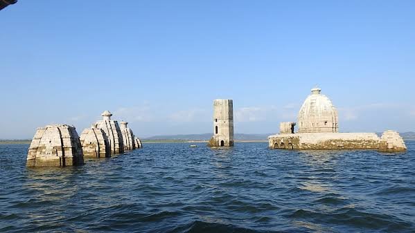
For most of the year, the ancient Bathu temples near Pong Dam sit completely submerged beneath the waters of Maharana Pratap Sagar — only reappearing each May and June, when the reservoir’s water level drops enough to reveal their stone structures once more. It’s a striking annual reminder of what this dam, once the tallest earthfill structure in India, actually cost the Kangra valley when it was built.
Pong Dam: Overview
| Parameter | Details |
| State | Himachal Pradesh |
| District | Kangra |
| Location | Khatiyar, just upstream of Talwara |
| River | Beas River, one of the five major rivers of the Indus basin |
| Dam type | Earth-fill embankment dam with gravel shell |
| Height | 133 metres (436 ft) — tallest earthfill dam in India at completion |
| Length | 1,951 metres (6,401 ft) |
| Base width | 610 metres |
| Crest width | 13.72 metres |
| Construction began | 1961 |
| Year completed | 1974 |
| Power station commissioned | 1978 to 1983 |
| Owner/operator | Bhakra Beas Management Board (BBMB) |
| Reservoir | Maharana Pratap Sagar (named after the Rajput ruler of Mewar) |
| Reservoir total capacity | 8.57 billion cubic metres (302.69 TMC) |
| Catchment area | 12,560 sq. km |
| Installed power capacity | 396–400 MW (6 x 66 MW turbines) |
| Families/people displaced | Over 20,000 families, reportedly up to 150,000 people |
| Submerged heritage site | Bathu temples, visible only May–June when water levels drop |
| Ramsar Wetland status | Designated 19 August 2002 |
| Recorded bird species | Over 220, including the Red-necked Grebe |
| Best time to visit | October to March |
The Beas River and the Second Phase of a Two-Dam Project
Pong Dam is built across the Beas River at Khatiyar in Kangra district, just upstream of Talwara, capturing water from a substantial catchment of 12,560 sq. km draining the Himalayan foothills. The Beas itself ranks among the five major rivers of the Indus basin, giving this dam genuine regional significance well beyond Himachal Pradesh’s own borders.
Pong forms the second phase of the broader Beas Project, following the earlier Pandoh Dam, located approximately 140 km upstream. A few points about this two-dam relationship:
- Pandoh Dam, as the first phase, primarily diverts Beas water toward the Sutlej system for hydroelectric generation, while Pong Dam serves as the major downstream storage reservoir
- Together, these two structures reflect a coordinated, multi-decade approach to harnessing the Beas for both power generation and irrigation across a wide swath of northwestern India
- The dam’s water ultimately supports irrigation needs extending across Himachal Pradesh, Punjab, Haryana, and Rajasthan, reflecting the Beas’s role within the broader Indus basin water-sharing framework governed by agreements like the Indus Waters Treaty
History: From a 1926 Idea to a 1974 Completion
The idea of harnessing the Beas at this location traces back remarkably far — as early as 1926, with the Punjab government ordering formal surveys of the Indus River and its tributaries the following year, in 1927. Despite this early conceptual groundwork, actual construction didn’t begin until 1961, nearly 35 years later, and wasn’t completed until 1974.
A few historical points worth noting:
- At the time of its completion, Pong Dam was the tallest earthfill dam of its type in India, a genuinely significant engineering achievement for the era
- The power station, a separate component of the overall project, was commissioned in stages between 1978 and 1983, several years after the dam structure itself was finished
- This extended, multi-decade timeline — from a 1926 conceptual survey to a fully operational power station by 1983 — spans nearly six decades of Indian water infrastructure planning across both colonial and post-independence administrations
The Human Cost: Displacement and a Contested Relocation
Pong Dam’s reservoir required displacing a substantial population from the Kangra valley. Documented accounts describe over 20,000 families being asked to leave their villages to make way for the dam, with some estimates placing the total number of people affected as high as 150,000.
A few points about this displacement:
- At least one detailed account specifically characterises the relocation plan implemented at the time as faulty, suggesting the resettlement process fell short of adequately addressing the needs of displaced communities
- This scale of displacement places Pong Dam among the more significant human relocation events associated with any single Indian dam project, reflecting the sheer size of the reservoir created
- As with many large Indian dam projects of this era, detailed, comprehensive official records addressing the full scope and adequacy of compensation and resettlement aren’t consistently accessible in public sources today, making community accounts and subsequent reporting important sources for understanding this history
Engineering Specifications
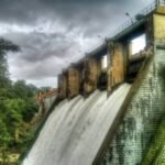
Pong Dam is built as an earth-fill embankment structure with a gravel shell, standing 133 metres (436 ft) tall and stretching 1,951 metres (6,401 ft) in length, with a base width of 610 metres and a crest width of 13.72 metres.
Core specifications:
- Height: 133 metres (436 ft)
- Length: 1,951 metres (6,401 ft)
- Base width: 610 metres
- Dam volume: 35.5 million cubic metres
- Spillway: 6 radial gates, chute type, discharge capacity 12,375 cubic metres per second
- Reservoir total capacity: 8.57 billion cubic metres (302.69 TMC)
- Installed power capacity: approximately 396–400 MW
This scale made Pong Dam a genuine engineering landmark at the time of its 1974 completion, and it remains one of India’s largest earthfill dam structures today.
A Temple That Only Appears in Summer
Among the many places and structures submerged when Pong Dam’s reservoir filled, the Bathu temples — locally known as Bathukiladi — stand out as a genuinely unique cultural loss with an unusual seasonal twist. This group of temples, dedicated to the goddess Parvati and Lord Shiva, now lies submerged beneath Maharana Pratap Sagar for most of the year.
However, unlike most submerged heritage sites lost permanently beneath a reservoir, the Bathu temples reappear seasonally:
- Between May and June each year, when the reservoir’s water level naturally decreases, the temple structures become accessible once again
- This seasonal reappearance has turned the Bathu temples into a genuinely distinctive pilgrimage and heritage tourism opportunity, drawing visitors specifically during this narrow annual window
- For anyone planning a visit specifically to see these temples, timing the trip precisely for the pre-monsoon low-water period is essential, since the site remains inaccessible for the rest of the year
A Ramsar Wetland and Rare Migratory Birds
Beyond its engineering and human history, Pong Dam’s reservoir has become one of India’s most significant wetland habitats. Officially designated a Ramsar Wetland of International Importance on 19 August 2002 under the name “Pong Dam Lake,” it holds genuine global conservation significance.
A few points about its ecological value:
- Over 220 bird species across 54 families have been recorded at the site, alongside 27 species of fish
- The reservoir is the only place in India where the rare Red-necked Grebe has been consistently sighted, a genuinely notable distinction for Indian birdwatchers
- Other notable species include the Bar-headed Goose, various plovers, terns, black-headed gulls, ducks, and egrets, reflecting the site’s importance as a stopover for birds crossing the Himalayas
- Nagrota Surian is widely regarded as the best location within the sanctuary for dedicated birdwatching
This combination of substantial reservoir scale and position at the base of the Dhauladhar range makes Pong Dam an internationally significant stopover point for migratory waterfowl navigating the Himalayan flyway.
Planning a Visit to Pong Dam
For anyone considering a trip:
- Getting there: The dam sits near Talwara in Kangra district, roughly 60 km southwest of Dharamsala
- Best season for general visits: October through March offers the most comfortable weather and peak birdwatching conditions, as migratory species arrive for the winter
- Best season for the Bathu temples: Specifically May and June, when reservoir water levels drop enough to reveal the submerged temple structures
- What to do: Watersports, boating, angling, and birdwatching are all popular activities on and around the reservoir
- Combine with Dharamsala: Given the relatively short distance, many visitors combine a Pong Dam trip with a broader Kangra valley itinerary including Dharamsala and the Dhauladhar range
FAQs
Q1. When exactly can I visit the submerged Bathu temples at Pong Dam?
The temples become accessible only between May and June each year, when the reservoir’s water level naturally drops before the monsoon refills it, so visitors specifically interested in seeing these temples should plan their trip precisely within this narrow seasonal window.
Q2. Why was Pong Dam’s relocation of displaced families considered problematic?
Detailed accounts describe the original relocation plan implemented for the more than 20,000 displaced families as faulty, though comprehensive official documentation addressing the full scope of this issue isn’t consistently accessible today, making it an area where community accounts remain an important historical source.
Q3. Is Pong Dam still the tallest earthfill dam in India today?
It was the tallest earthfill dam in India at the time of its 1974 completion, and while other significant earthfill structures have since been built elsewhere in the country, Pong Dam remains one of India’s largest and most historically significant dams of this type.
Q4. Why is Pong Dam considered such an important birdwatching destination specifically?
Its position at the base of the Himalayan foothills makes it a critical stopover point for migratory birds crossing the mountain range, and it holds the unique distinction of being the only confirmed location in India for sightings of the rare Red-necked Grebe, alongside over 220 other recorded bird species.