
Long before the Kaveri crosses into Tamil Nadu and becomes the centre of one of India’s most contested interstate water disputes, it picks up its very first significant tributary in the misty hills of Kodagu — and that tributary has its own dam. Harangi Dam holds the distinction of being built across the Kaveri’s first major tributary, right in the district where the sacred river itself is born, making it a genuinely foundational piece of infrastructure for the entire Kaveri basin system.
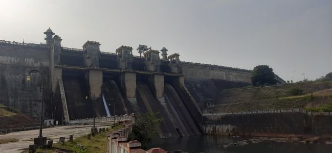
Harangi Dam: Overview
| Parameter | Details |
| State | Karnataka |
| District | Kodagu (Coorg) |
| Location | Hudgur village, Kushalnagar taluk |
| Distance from Kushalnagar | Approx. 9 km |
| Distance from Madikeri | Approx. 36 km |
| River | Harangi River — the first major tributary of the Kaveri |
| River origin | Pushpagiri Hills, Western Ghats |
| River length (to confluence) | 50 km |
| Confluence point | Near Kudige, 5 km north of Kushalnagar |
| Dam type | Masonry dam |
| Height | Approx. 47–53 metres (varies by source) |
| Length | Approx. 845–846 metres (2,775 ft) |
| Construction began | 1969/1970 |
| Year completed | 1982 |
| Operator | Karnataka Irrigation Department |
| Reservoir total capacity | 8.50 TMC ft |
| Catchment area | 419.58 sq. km |
| Reservoir surface area | 20.03 sq. km |
| Hydroelectric project | Harangi Hydroelectric Project, 9 MW (2 x 4.5 MW), commercial from July 1999 |
| Nearby attractions | Harangi Tree Park, Elephant Camp, Dubare forest |
| Best time to visit | August to September (fullest reservoir) |
The Harangi River: The Kaveri’s First Major Tributary
The Harangi River rises in the Pushpagiri Hills of the Western Ghats, within Kodagu district — the very region where the Kaveri itself originates near Talakaveri. As the first significant tributary to join the main Kaveri, the Harangi carries a genuine, documented significance for the broader river system’s water balance.
A few points about this relationship:
- The Harangi flows for approximately 50 km from its origin before joining the Kaveri near Kudige, just 5 km north of Kushalnagar
- Its catchment, spanning 419.58 sq. km, depends almost entirely on heavy rainfall from the southwest monsoon, filling the reservoir through the wet season before gradually depleting between December and May
- Because the Harangi contributes to the Kaveri so early in its course, water management decisions at Harangi Dam have implications for the broader river system, even though the dam itself operates as a relatively modest, locally significant structure compared to major downstream dams like the Krishna Raja Sagara or Mettur
History and Construction
Harangi Dam’s construction began around 1969–1970, driven by the straightforward agricultural necessity common across much of Karnataka: reliable water supply for irrigation in a region where farming remains a central occupation. The Karnataka Irrigation Department oversaw the project, which was completed and opened for operation in 1982.
A few historical points worth noting:
- The dam is frequently described locally as the first dam built in this part of the Kaveri basin, within Kodagu district itself, distinguishing it from much older but far more downstream structures like Mettur Dam in Tamil Nadu, built over four decades earlier
- Its construction reflects Karnataka’s broader mid-to-late-20th-century push to secure irrigation infrastructure across the state’s river valleys
- The masonry construction technique used reflects standard engineering practice for medium-scale Karnataka dams of this era
Engineering Specifications
Harangi Dam is built as a masonry structure, with height figures across various sources ranging from approximately 47 to 53 metres, and a consistently cited length of around 845 to 846 metres (2,775 ft).
Core specifications:
- Height: approximately 47–53 metres, depending on the specific source
- Length: approximately 845–846 metres (2,775 ft)
- Total reservoir capacity: 8.50 TMC ft
- Catchment area: 419.58 sq. km
- Reservoir surface area: 20.03 sq. km
This scale places Harangi as a medium-sized irrigation dam, modest compared to Karnataka’s largest Kaveri basin structures, but significant given its position at the very source region of the river system.
A Later Addition: Hydroelectric Power on the Left Bank
Decades after the dam’s original 1982 completion, the Harangi Hydroelectric Project was added, developed by Energy Development Company Limited (EDCL) on the dam’s left bank, running parallel to the existing left bank irrigation canal.
A few points about this later addition:
- Construction of the hydroelectric component began in April 1997, and the project reached full commercial operation by July 1999
- With an installed capacity of 9 MW (2 x 4.5 MW), the project falls under the “small” hydropower category, defined as projects generating between 3 and 25 MW
- The project’s estimated cost of Rs 11.06 crore escalated significantly to an actual cost of Rs 58 crore during implementation
- A planned Phase-II expansion, targeting an additional 6 MW unit, remains under consideration
This retrofit of hydroelectric capacity onto an existing irrigation dam decades after its original construction reflects a common pattern across Indian water infrastructure, where power generation is added later to make more complete use of water already being released for agricultural purposes.
Harangi’s Elephant Camp and Tree Park
Beyond its engineering and agricultural significance, Harangi Dam has developed a distinctive recreational identity, anchored by amenities not found at most Indian dam sites. The Harangi Tree Park and an associated Elephant Camp sit near the reservoir, drawing visitors interested in more than just scenic water views.
A few points about this recreational dimension:
- The Elephant Camp reflects Karnataka’s broader tradition of forest department elephant training and care facilities, similar in spirit to the well-known Dubare Elephant Camp located in the same general Kodagu forest belt
- The surrounding Dubare forest area, with its verdant trees and grasslands, adds to the site’s natural appeal
- Harangi Backwater Resorts have developed around the reservoir, offering accommodation options for visitors wanting more than a day trip
- As the only major reservoir in the Coorg (Kodagu) region, Harangi holds a somewhat unique status as a water-based destination within a district otherwise known primarily for its coffee plantations and hill scenery
Planning a Visit to Harangi Dam
For anyone considering a trip:
- Getting there: The dam sits roughly 9 km from Kushalnagar and about 36 km from Madikeri, accessible by road
- Best season: August through September offers the fullest reservoir following the monsoon, though the dam remains a pleasant destination through the cooler months as well
- What to see: Short walking paths along the dam offer views of both the reservoir side and the flowing river below the gates, along with the nearby Tree Park and Elephant Camp
- Combine with Dubare: Given the proximity to the broader Dubare forest area, visitors can pair a Harangi Dam trip with elephant camp visits and other Kodagu forest attractions
FAQs
Q1. Is Harangi Dam actually built on the Kaveri River itself, or on a tributary?
It’s built on the Harangi River, which is the first major tributary of the Kaveri, joining the main river near Kudige — the dam is often locally described as the “first dam on the Kaveri” in the sense of being the first significant dam built within the river’s home district of Kodagu, rather than being on the Kaveri’s main channel itself.
Q2. When is the best time to see Harangi Dam’s reservoir at its fullest?
August through September, immediately following the peak of the southwest monsoon, typically offers the fullest reservoir, since the dam depends entirely on monsoon rainfall and gradually depletes between December and May.
Q3. Can visitors interact with elephants at the Harangi Elephant Camp?
The camp reflects Karnataka’s forest department elephant care tradition similar to the nearby Dubare Elephant Camp, though visitors should check current visiting protocols and any interaction guidelines directly with the forest department before planning a visit specifically for this purpose.
Q4. Why was hydroelectric power added to Harangi Dam so many years after its original construction?
The Harangi Hydroelectric Project was developed in the late 1990s specifically to generate additional value from water already being released through the dam’s left bank irrigation canal, a common retrofit approach for irrigation dams built without power generation originally in mind.


