According to legend, when Lord Rama caught a tribal couple named Kuravan and Kurathi staring at Sita bathing in the Periyar River, he cursed them to become two granite hills, forever separated by the flowing water between them — promising only that they would finally be reunited in the age of Kaliyuga. Nearly two thousand years later, engineers built a dam that literally joined those two hills together, and locals still say the ancient promise was finally kept the day Idukki Dam was completed.
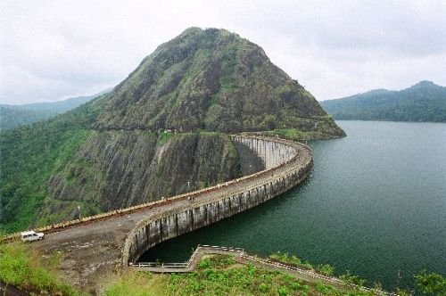
Idukki Dam: Overview
| Parameter | Details |
| State | Kerala |
| District | Idukki |
| Location | Kuravanmala gorge, between Kuravan (839 ft) and Kurathi (925 ft) hills |
| River | Periyar River |
| Distance from river source | Approx. 40–50 km downstream |
| Dam type | Double-curvature thin arch dam |
| Height | Approx. 167.68–168.91 metres (one of the highest arch dams in Asia) |
| Owner/builder | Kerala State Electricity Board (KSEB) |
| Original idea proposed | 1919 |
| Construction began | 30 April 1969 |
| Reservoir storage began | February 1973 |
| First power generation | 4 October 1975 |
| Commercial operation commissioned | 12 February 1976, by PM Indira Gandhi |
| Foreign assistance | Government of Canada (long-term loans and grants); consulting by SNC Inc., Canada |
| Associated dams | Cheruthoni Dam and Kulamavu Dam, forming one combined reservoir |
| Combined reservoir area | Approx. 60 sq. km |
| Power station | Moolamattom, built inside underground rock caves |
| Installed power capacity | 780 MW |
| Local legend | Kuravan and Kurathi, cursed by Lord Rama, reunited in the Kaliyuga through the dam |
| Best time to visit | September to May |
The Periyar River and the Idukki Gorge
Idukki Dam sits across the Periyar River, Kerala’s largest river, at a point roughly 40 to 50 km downstream from its source, exactly where the river passes through a dramatically narrow gorge between two granite hills. This gorge, locally called the Idukki gorge, gives the entire district its name — “Idukki” derives from the Malayalam word “Idukku,” meaning a narrow ravine.
A few points about this location’s geological significance:
- The two flanking hills, Kuravanmala (839 ft) and Kurathimala (925 ft), provided exactly the kind of narrow, solid granite formation needed to support an arch dam design
- Arch dams work by transferring water pressure sideways into the surrounding rock formations rather than relying purely on their own mass, making a site like this — with two tall, closely spaced hills — genuinely ideal
- This specific gorge configuration is precisely why the site was identified as suitable for what would become one of Asia’s tallest arch dams
A Legend, a Hunting Trip, and Decades of Delay: History
The idea of building a dam at this location was first proposed in 1919, when an Italian engineer named Jacob submitted a report to the Travancore government — a proposal that was initially rejected. The project’s story took a more memorable turn in 1922, when Shri Kolumban, head of the local Oorali (or Araya) tribe, guided the Malankara Estate Superintendent and his friend A.C. Thomas Edattu through the forest during a hunting trip, showing them the exact gorge where the dam now stands and sharing the legend of Kuravan and Kurathi.
Thomas was reportedly so struck by the sight of water flowing between the two hills that he became convinced of the site’s potential for an arch dam. What followed was a genuinely prolonged path toward realisation:
- In 1932, W.J. John of Malankara Estate submitted a formal report to the Travancore government on the possibility of constructing a dam here for power generation
- In 1935, Travancore Assembly member K.A. Narayana Pillai brought the project to government attention, though it received little immediate action
- Italian engineers Angelo Omedeyo and Clantheyo Masele conducted a technical study in 1937, but the project still didn’t move forward
- A preliminary investigation report followed in 1947, prepared by P. Joseph John, then Chief Electrical Engineer to the Travancore government
- Only in 1956 did the Central Water and Power Commission conduct a detailed investigation at the government’s request, with a full project report finally prepared in 1961 and Planning Commission sanction granted the same year
This nearly 40-year gap between the original 1919 proposal and the 1961 sanction reflects just how long ambitious hydroelectric projects could take to move from concept to approval in pre- and post-independence India.
Foreign Aid and Finally, Construction
Once sanctioned, the Idukki project’s scope was expanded through Canadian foreign assistance. The Government of Canada provided long-term loans and grants to support the project, with the Canadian consulting engineering firm SNC Inc. advising and assisting project engineers throughout construction — a revised, enlarged project report was drawn up around 1965–66 to reflect this expanded scope.
Construction of the arch dam finally began on 30 April 1969, exactly half a century after the idea was first proposed. The subsequent milestones came more quickly:
- Storage of water in the Idukki reservoir began in February 1973
- The first generating unit underwent a trial run on 4 October 1975
- Commercial operation of the power station was formally commissioned on 12 February 1976, by Prime Minister Indira Gandhi
This meant the dam went from active construction to full commercial power generation in under seven years — a considerably faster execution phase than the decades of planning and deliberation that had preceded it.
Engineering Specifications: A Double-Curvature Marvel
Idukki Dam is technically classified as a double-curvature, parabolic, thin arch dam — a genuinely sophisticated engineering design achieving considerable height (approximately 168 metres) while using a relatively thin, curved concrete structure rather than the massive material volume required by gravity dams of similar height.
Key engineering features:
- Height: approximately 167.68–168.91 metres, placing it among the highest arch dams in Asia
- Design type: double-curvature (curved both horizontally and vertically) thin arch construction
- Structural principle: transfers water pressure into the flanking Kuravan and Kurathi hills rather than relying purely on the dam’s own weight
- Owner and builder: Kerala State Electricity Board
This design approach allowed engineers to achieve remarkable height using significantly less concrete than a comparable gravity dam would require — a genuine engineering efficiency made possible specifically by the narrow, solid-rock gorge the site provided.
Three Dams, One Lake, and a Power House Inside a Cave
Idukki Dam doesn’t work alone. Together with two companion structures — the Cheruthoni Dam and the Kulamavu Dam — it forms a single combined reservoir spanning approximately 60 sq. km, all feeding water toward one shared power generation system.
Perhaps the most distinctive feature of the entire project is where that power is actually generated: the Moolamattom power house, built inside underground rock caves rather than as a conventional surface structure. This unusual design choice reflects both the terrain’s geological suitability for excavated underground infrastructure and considerations around protecting sensitive power generation equipment.
Key details of the broader power system:
- Installed capacity: 780 MW, generated at the Moolamattom underground power station
- Combined reservoir: fed by three separate dams (Idukki, Cheruthoni, and Kulamavu) working as a single integrated system
- Water route: water travels from the combined reservoir through tunnels to reach the underground turbines at Moolamattom, a considerable distance from the dam sites themselves
This combination of an ancient legend, a mid-century engineering marvel, and an underground cave power station gives Idukki Dam a genuinely distinctive identity among India’s major hydroelectric projects.
Planning a Visit to Idukki Dam
For anyone considering a trip:
- Getting there: The dam sits within Idukki district, accessible via well-connected roads from Kochi and other major Kerala towns
- Best season: September through May offers favourable weather for visiting, avoiding the heaviest monsoon rains
- What to see: Viewpoints near the dam offer views across the Kuravan and Kurathi hills and the reservoir, with the legend adding cultural depth to the visit
- Entry considerations: As an active hydroelectric facility, visitor access, timings, and any entry fees should be confirmed with Kerala Tourism or the KSEB before planning a trip
FAQs
Q1. Is the legend of Kuravan and Kurathi historically documented, or purely local folklore?
It’s a locally told mythological legend passed down for generations rather than a historically documented event, but it holds genuine cultural significance for the region and directly influenced the naming and early identification of the dam site.
Q2. Why did it take from 1919 to 1969 — exactly 50 years — before construction actually began?
The project went through multiple rounds of proposals, technical studies, and government reports across this period, reflecting the genuine complexity of securing sustained government attention, technical validation, and eventually foreign financial assistance for such an ambitious engineering undertaking.
Q3. Why is the power station located underground in a cave rather than at the dam site itself?
The Moolamattom power house was built inside underground rock caves to take advantage of the terrain’s geological suitability for excavated infrastructure, with water channelled from the combined reservoir through tunnels to reach the turbines at this separate underground location.
Q4. Are Idukki, Cheruthoni, and Kulamavu dams the same thing, or three separate structures?
They are three separate dams that together create a single combined reservoir spanning approximately 60 sq. km, all feeding water toward the shared Moolamattom power generation system, making them functionally integrated even though each is a distinct physical structure.