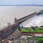
Long before “ecotourism” became a buzzword in Indian travel marketing, Thenmala had already claimed the title — becoming India’s first officially planned ecotourism destination in 1998, built around a reservoir where three separate rivers converge. The name itself tells a story: “Thenmala” means “Honey Hill” in Malayalam, a reference to the region’s reputation for producing exceptionally high-quality honey, thanks to the unique biodiversity surrounding this Kollam district landmark.

Thenmala Dam: Overview
| Parameter | Details |
| State | Kerala |
| District | Kollam |
| Location | Thenmala, near Punalur town |
| Distance from Kollam city | Approx. 63 km |
| Distance from Thiruvananthapuram | Approx. 72 km |
| Also known as | Parappar Dam, Kallada Dam |
| Rivers | Confluence of the Shendurney (Chenduruney), Kazhuthurutty, and Kulathupuzha rivers, feeding the Kallada River |
| Height | 85.35 metres (280 ft) |
| Length | 335 metres (1,099 ft) |
| Spillways | 3 — Ogee with radial gate and auxiliary Labyrinth type |
| Reservoir total capacity | 524 million cubic metres |
| Reservoir surface area | Approx. 23–26 sq. km — the largest reservoir in Kerala |
| Catchment area | 549 sq. km |
| Project name | Kallada Irrigation and Tree Crop Development Project (KIP) |
| Foundation stone laid | 26 January 1972, by T. K. Divakaran |
| Commissioned | 26 May 1986, by K. Karunakaran |
| Original project cost | Rs 13.28 crore |
| Status | Largest irrigation project in Kerala |
| Ecotourism designation | India’s first planned ecotourism destination, launched 1998 |
| Managing body | Thenmala Eco-Tourism Promotional Society (Government of Kerala) |
| Surrounding protected area | Shendurney Wildlife Sanctuary |
| Best time to visit | October to February |
A Dam Where Three Rivers Meet
Thenmala Dam occupies a genuinely distinctive hydrological position — built precisely at the confluence of three separate rivers: the Shendurney (also spelled Chenduruney), the Kazhuthurutty, and the Kulathupuzha. All three feed into the broader Kallada River, giving this single dam site an unusually complex catchment relative to its scale.
A few points about this setting:
- This three-river confluence positioning allowed engineers to create a reservoir spanning approximately 23 to 26 sq. km, the largest artificial lake in Kerala
- The reservoir spreads along the middle of the Shendurney Wildlife Sanctuary, meaning the water body itself sits embedded within genuinely significant protected forest habitat rather than adjacent to it
- This combination of a multi-river confluence and protected sanctuary positioning gives Thenmala’s catchment a level of ecological richness uncommon among Kerala’s other major dams
History: Building Kerala’s Largest Irrigation Project
Thenmala Dam’s origins trace to the 1960s, when it was conceived as a central component of the Kallada Irrigation and Tree Crop Development Project (KIP) — a scheme aimed at establishing what would become Kerala’s largest irrigation project. Formal groundwork began with the foundation stone being laid on 26 January 1972 by T. K. Divakaran, though the dam wouldn’t be completed and commissioned for another fourteen years.
A few historical points worth noting:
- The dam was finally completed in 1986 and formally commissioned on 26 May that year by K. Karunakaran, alongside the broader Kallada Irrigation Project
- The original project cost was estimated at Rs 13.28 crore, a figure reflecting the scale of infrastructure required to harness three converging rivers into a single coordinated irrigation and power system
- This 14-year gap between foundation stone and commissioning reflects the genuine complexity of coordinating a project spanning multiple river confluences within challenging Western Ghats terrain
Engineering Specifications
Thenmala Dam stands 85.35 metres (280 ft) tall and stretches 335 metres (1,099 ft) in length, fitted with three spillways combining an Ogee design with radial gates and an auxiliary Labyrinth-type spillway — a relatively sophisticated combination of spillway technologies for a dam of this era.
Core specifications:
- Height: 85.35 metres (280 ft)
- Length: 335 metres (1,099 ft)
- Spillways: 3, combining Ogee, radial gate, and Labyrinth designs
- Reservoir total capacity: 524 million cubic metres
- Reservoir active capacity: 507 million cubic metres
- Catchment area: 549 sq. km
This mix of spillway types reflects the specific engineering challenge of managing flood discharge from a catchment fed by three converging rivers simultaneously, requiring more nuanced flow control than a single spillway design would typically provide.
India’s First Planned Ecotourism Destination
Thenmala’s most distinctive claim to fame arrived over a decade after the dam’s completion. In 1998, the reservoir and surrounding area became the site of India’s first officially planned ecotourism destination, developed and managed by the Thenmala Eco-Tourism Promotional Society, a Government of Kerala undertaking.
A few points about this pioneering designation:
- Unlike destinations where tourism developed organically around existing infrastructure, Thenmala’s ecotourism identity was deliberately planned from the outset, integrating recreational activities with genuine environmental education
- The project explicitly aims to balance opportunities for fun, adventure, and leisure with teaching visitors about eco-friendly practices in tourism development
- This deliberate, government-designed approach to ecotourism made Thenmala a genuine template that later influenced how other Indian destinations approached sustainable tourism development
The name “Thenmala” itself — meaning Honey Hill — reflects the region’s long-standing reputation for producing exceptionally high-quality honey, a distinction attributed to the area’s unique biological diversity and forest ecosystem, predating the dam and formal ecotourism designation by generations.
Inside Shendurney Wildlife Sanctuary: What Visitors Can Do
Thenmala’s reservoir sits within the Shendurney Wildlife Sanctuary, giving the site a genuine dual identity as both functioning water infrastructure and a significant protected forest ecosystem. This combination has translated into a genuinely varied set of visitor activities:
- Boating on the reservoir itself, offering scenic views across Kerala’s largest artificial lake
- Trekking and adventure activities, including a Burma Bridge and hanging bridge for visitors seeking a more thrilling experience within the sanctuary
- A deer rehabilitation centre, where visitors can observe deer in a natural forest setting
- A traditional tree house exhibit, offering insight into how forest-dwelling communities historically built elevated shelters to stay safe from wild animals
- Nearby Palaruvi Waterfall, a popular natural attraction within reasonable distance of the main ecotourism zone
- The Kannara railway bridge, an additional point of scenic and engineering interest near Thenmala
This range of activities — spanning wildlife observation, adventure sports, cultural education, and natural scenery — reflects the genuinely comprehensive vision behind Thenmala’s 1998 ecotourism designation, distinguishing it from many other Indian dam destinations that offer scenic views alone.
Planning a Visit to Thenmala Dam
For anyone considering a trip:
- Getting there: Thenmala sits roughly 63 km from Kollam city and about 72 km from Thiruvananthapuram, accessible by road, with the nearest major town being Punalur
- Best season: October through February offers the most comfortable weather for the trekking, boating, and adventure activities the destination is known for
- What to see: A well-rounded day or overnight trip can combine dam and reservoir views, the deer rehabilitation centre, adventure bridges, and a visit to nearby Palaruvi Waterfall
- Planning ahead: Given the destination’s managed ecotourism structure, checking current activity bookings and timings through the Thenmala Eco-Tourism Promotional Society before visiting is advisable, particularly for adventure activities like the Burma Bridge
FAQs
Q1. Is Thenmala Dam the same as the Kallada Dam or Parappar Dam mentioned in some sources?
Yes — all three names refer to the same structure, with “Thenmala Dam” being the most commonly used name, “Parappar Dam” referencing the specific dam site, and “Kallada Dam” referring to its connection to the broader Kallada Irrigation Project.
Q2. Why did it take 14 years between laying the foundation stone and commissioning the dam?
The extended timeline reflects the genuine engineering complexity of coordinating a project built at the confluence of three separate rivers within challenging Western Ghats terrain, a scale of undertaking that required considerably more time than a single-river dam project of similar size.
Q3. What exactly makes Thenmala “India’s first planned ecotourism destination” rather than just a tourist-friendly dam?
Unlike destinations where tourism developed organically over time, Thenmala’s ecotourism infrastructure was deliberately designed and launched in 1998 by a dedicated Government of Kerala body specifically to balance recreational activities with environmental education, making it a genuine planning template rather than an incidental tourist attraction.
Q4. Can I combine a Thenmala Dam visit with other nearby Kerala attractions in one trip?
Yes — given its proximity to Palaruvi Waterfall, the Kannara railway bridge, and its position within the broader Shendurney Wildlife Sanctuary, Thenmala naturally combines with a fuller day or multi-day itinerary covering these nearby natural and scenic attractions.