Two watchtowers stand at opposite ends of the world’s longest earthen dam — Gandhi Minar to the north, Nehru Minar to the south — and the nearly 26 kilometres of earth and concrete stretching between them quite literally joins the two men most associated with modern India’s founding. Hirakud Dam earned this symbolism honestly: it was one of independent India’s very first major infrastructure achievements, built to finally tame a river whose floods had devastated eastern India for generations.
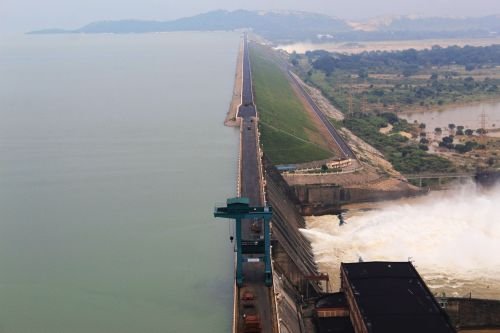
Hirakud Dam: Overview
| Parameter | Details |
| State | Odisha |
| District | Sambalpur |
| Distance from Sambalpur | Approx. 10–16.5 km |
| River | Mahanadi River |
| Dam type | Composite — earth, concrete, and masonry |
| Total length (with dykes) | 25.79 km — world’s longest earthen dam |
| Main masonry dam length | 4.8 km |
| Height | 60.96 metres (200 ft) |
| Foundation stone laid | 15 March 1946, by Sir Hawthorne Lewis, Governor of Odisha |
| Construction milestones | Nehru laid first concrete, 12 April 1948; construction largely complete, 1953 |
| Formally inaugurated | 13 January 1957, by Jawaharlal Nehru |
| Fully operational | 1966 |
| Construction cost | Approx. ₹101 crore (equivalent to roughly $1.1 billion in 2023 terms) |
| Spillway | 64 sluice gates and 34 crest gates |
| Spillway capacity | 42,450 cubic metres/second |
| Reservoir | Hirakud Reservoir |
| Reservoir total capacity | 5.896 billion cubic metres (205.56 TMC ft effective) |
| Reservoir length | Approx. 55 km |
| Catchment area | 83,400 sq. km |
| Installed power capacity | 347.5 MW (Burla and Chiplima power houses) |
| Irrigated area | 2,355 sq. km |
| Notable landmarks | Gandhi Minar (north) and Nehru Minar (south) |
| Ramsar wetland status | Declared 12 October 2021 |
| Best time to visit | October to February |
The Mahanadi River and the Flood That Started It All
Hirakud Dam sits across the Mahanadi River, which rises in Raipur district of Chhattisgarh and flows approximately 851 km before emptying into the Bay of Bengal. This particular stretch of the river, near Sambalpur in Odisha, was chosen specifically because of the site’s suitability for a large multipurpose storage project — and because of urgent necessity.
The project’s origins trace directly to a specific catastrophe: the devastating Mahanadi floods of 1937, which caused widespread destruction across eastern India and made clear that the river’s unpredictable flow needed serious engineering intervention. Sir M. Visvesvaraya conducted preliminary studies related to this broader flood-control challenge, laying early groundwork for what would eventually become the Hirakud project.
A few points about this river’s significance:
- The Mahanadi’s catchment feeding Hirakud spans 83,400 sq. km, reflecting the river’s status as one of eastern India’s most significant waterways
- Flood control remained the dam’s primary original motivation, even as irrigation, power generation, and navigation were incorporated into its eventual multipurpose design
- The river’s history of destructive flooding made Hirakud a genuinely urgent priority in the years immediately following India’s independence
A 1946-to-1966 Journey: History and Construction
Hirakud Dam’s development timeline spans a genuinely significant chapter of India’s early independence-era infrastructure planning. The foundation stone was laid on 15 March 1946 by Sir Hawthorne Lewis, then Governor of Odisha, while India was still under British colonial administration. A detailed project report followed in June 1947, just before independence.
The project then became one of the very first major infrastructure undertakings of independent India:
- On 12 April 1948, Prime Minister Jawaharlal Nehru personally laid the first batch of concrete for the dam’s construction
- In 1952, the Mazumdar Committee reviewed the project’s technical and economic feasibility, providing additional oversight and validation
- Construction of the dam itself was largely completed by 1953
- Irrigation and power generation began in 1956, with Nehru formally inaugurating the completed dam on 13 January 1957
- The project reached its full operational potential only by 1966, nearly two decades after Nehru’s initial groundbreaking
This extended path from 1946 foundation stone to 1966 full operation places Hirakud among the foundational infrastructure projects that shaped Nehru’s vision of large dams as the “temples of modern India” — a philosophy that would go on to define India’s approach to major water infrastructure for decades.
Engineering Specifications: Twenty-Five Kilometres of Earth and Concrete
Hirakud Dam’s defining engineering achievement is sheer scale. Its total length, including earthen dykes extending on either side of the main masonry section, reaches 25.79 km — making it the longest earthen dam in the world. The main masonry dam section itself spans 4.8 km, with the remainder consisting of extensive earthen embankment.
Core specifications:
- Total length: 25.79 km, including dykes
- Main dam length: 4.8 km
- Height: 60.96 metres (200 ft)
- Spillway: 64 sluice gates and 34 crest gates, with a discharge capacity of 42,450 cubic metres per second
- Reservoir total capacity: 5.896 billion cubic metres
This composite construction — combining earth, concrete, and masonry across such an extensive length — reflects the sheer scale needed to seal off the wide Mahanadi valley at this location, a stark contrast to the narrow-gorge dams built at many other Indian sites.
What the Dam Controls, Irrigates, and Powers
Hirakud Dam’s multipurpose design has delivered substantial benefits across Odisha since its completion:
- Flood control: Its original and most urgent purpose, moderating the Mahanadi’s historically destructive flood patterns for downstream communities
- Irrigation: Supporting approximately 2,355 sq. km of agricultural land across the region
- Hydroelectric power: Generating 347.5 MW through two power houses — Burla, with a combination of Kaplan-type turbines, and Chiplima, with three 24 MW units
- Navigation: Supporting river navigation along this stretch of the Mahanadi
Construction of the dam required submerging approximately 596 sq. km of land to create the reservoir, a significant footprint reflecting the scale of the project’s overall impact on the surrounding landscape.
A Ramsar Wetland and Odisha’s Industrial Anchor
Hirakud Reservoir’s ecological significance was formally recognised on 12 October 2021, when it was declared a Ramsar site — an international designation for wetlands of particular ecological importance. This recognition reflects the reservoir’s substantial scale, spanning roughly 743 to 746 sq. km at full capacity with a shoreline stretching approximately 640 km, making it one of Asia’s largest artificial lakes.
Beyond its ecological and agricultural significance, the Hirakud area has also become an important industrial centre. The nearby town serves as a hub for HINDALCO Industries, a major Indian aluminium and copper manufacturing company, reflecting how the dam’s power and water resources have supported industrial development alongside its agricultural and flood-control functions.
Planning a Visit to Hirakud Dam
For anyone considering a trip:
- Getting there: The dam sits roughly 10–16.5 km from Sambalpur, well-connected by road
- Best season: October through February offers the most comfortable weather and typically the fullest reservoir following the monsoon
- What to see: The Gandhi Minar and Nehru Minar towers at either end of the dam offer scenic viewpoints across the reservoir, along with the sheer visual scale of driving along one of the world’s longest earthen embankments
- Combine with Sambalpur: Given the dam’s proximity to Sambalpur, visitors can combine a trip with the town’s broader attractions, including its well-known handloom textile heritage
FAQs
Q1. Why are the two towers at either end of Hirakud Dam named after Gandhi and Nehru specifically?
The naming reflects the dam’s status as one of independent India’s earliest major infrastructure achievements, with Gandhi Minar to the north and Nehru Minar to the south symbolically anchoring a project deeply tied to the vision and early leadership of newly independent India.
Q2. Is Hirakud Dam actually longer than famous dams like Bhakra or Tehri?
Yes, by total length — at 25.79 km including its earthen dykes, Hirakud is dramatically longer than height-focused dams like Bhakra (520 m) or Tehri, though those dams are considerably taller, reflecting the fundamentally different terrain and engineering challenges each site presented.
Q3. Why did it take until 1966 for Hirakud Dam to become fully operational, even though it was inaugurated in 1957?
While the dam was formally inaugurated by Nehru in 1957 with irrigation and power generation already underway from 1956, reaching the project’s full designed operational potential — including complete irrigation network development and power generation capacity — took until 1966.
Q4. What does the Ramsar site designation mean for visitors to Hirakud Reservoir?
The 2021 Ramsar designation recognises Hirakud Reservoir’s importance as a wetland ecosystem, meaning visitors may notice greater conservation focus and potentially restricted access in certain ecologically sensitive areas, alongside the reservoir’s continued role as a major tourist destination.