When the foundation stone for this project was laid, it was named “Priyadarshini” — the epithet by which Indira Gandhi was widely known — making it one of the more personally significant infrastructure projects tied to her legacy in the Deccan. The Priyadarshini Jurala Project holds a genuine distinction beyond its naming, too: it was the very first irrigation project ever built on the Krishna River within what is now Telangana.
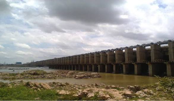
Jurala Dam: Overview
| Parameter | Details |
| State | Telangana |
| District | Jogulamba Gadwal |
| Location | Dharoor mandal |
| Distance from Gadwal | Approx. 15 km |
| Distance from Atmakur | Approx. 16 km |
| Official name | Priyadarshini Jurala Project (PJP) |
| River | Krishna River |
| Distinction | First irrigation project built on the Krishna River in Telangana |
| Dam type | Composite — earthen embankment with masonry/concrete barrage |
| Barrage height | 40 metres |
| Barrage length | Approx. 1,322 metres |
| Total dam length (with earthen wings) | Approx. 4,534 metres |
| Spillway gates | 79, radial type |
| Spillway capacity | 35,396 cumecs |
| Year completed | 1995–1996 |
| Original design full capacity | 11.94 TMC |
| Reduced capacity (2013, due to siltation) | Under 7 TMC |
| Catchment area | 129,499 sq. km |
| Installed power capacity | 234 MW |
| Left Main Canal | 85.277 km, ayacut 69,117 acres |
| Right Main Canal | 46.275 km, ayacut 35,657 acres |
| Nearby pilgrimage site | Kurvapur (Dattatreya shrine) |
| Position in cascade | Upstream of Lower Jurala Hydro Electric Project |
| Best time to visit | October to February |
The Krishna River and Jurala’s Place in a Three-Dam Cascade
Jurala Dam sits across the Krishna River, one of peninsular India’s largest rivers, in Dharoor mandal of Jogulamba Gadwal district. Its position places it within a coordinated sequence of hydroelectric infrastructure along this stretch of the river:
- Jurala Project, the main storage and diversion structure
- Lower Jurala Hydro Electric Project, located downstream near Mulamalla village, a run-of-the-river scheme using six 40 MW bulb-type turbines commissioned between 2013 and 2016
- The broader cascade allows water released from Jurala for power generation to be reused for additional generation downstream, maximising the efficiency of every unit of water passing through the system
This cascade relationship isn’t purely theoretical — it has had real operational consequences. On 30 July 2014, a sudden release of floodwater from the Jurala Project inundated equipment at the still-under-construction Lower Jurala Hydro Electric Project, damaging assemblies for units under erection and contributing to delays in that downstream project’s completion.
History: Indira Gandhi and Telangana’s First Krishna River Project
The Jurala Project’s foundation stone was laid by Indira Gandhi, and the project’s official name — Priyadarshini Jurala Project — directly references her widely used epithet, “Priyadarshini,” meaning “one who is pleasant to look at” or “of pleasing countenance.” This naming choice reflects the project’s significance at the time of its conception, undertaken specifically for the welfare and development of the district.
A few historical points worth noting:
- Jurala holds the distinction of being the first project built on the Krishna River within what is now Telangana state, a significant milestone given the Krishna’s importance across the broader Deccan region
- The project was completed in 1995, with some records citing 1996 as the final commissioning year
- Its location near Kuravapur, a significant pilgrimage site, adds a layer of regional cultural context to the project’s placement along this particular stretch of the Krishna
Engineering Specifications
Jurala Dam is built as a composite structure, combining a masonry and concrete barrage section with substantial earthen embankment wings extending on either side. The main barrage stands 40 metres tall and stretches approximately 1,322 metres, while the total dam length including its earthen sections reaches roughly 4,534 metres.
Core specifications:
- Barrage height: 40 metres
- Barrage length: approximately 1,322 metres
- Total dam length (including earthen wings): approximately 4,534 metres
- Spillway: 79 radial gates, with a discharge capacity of 35,396 cumecs
- Catchment area: 129,499 sq. km, reflecting its position on the main Krishna River rather than a smaller tributary
This substantial catchment area — significantly larger than most tributary dams profiled elsewhere — reflects Jurala’s position directly on the Krishna’s main course, capturing flow that has already accumulated across a vast upstream drainage area spanning multiple states.
A Rapidly Shrinking Reservoir: The Siltation Crisis
Perhaps the most striking part of Jurala’s operational history is the severity of its siltation problem. The project was originally designed with a full reservoir capacity of 11.94 TMC at a full reservoir level of 1,045 ft. By August 2013, accumulated sediment had reduced this capacity to an estimated 9.74 TMC, and further reports indicate the capacity has continued declining to under 7 TMC — representing a loss of more than 40% of the reservoir’s original design capacity within roughly two decades of operation.
This decline carries genuine practical consequences:
- Reduced storage capacity directly limits how much water the reservoir can hold and release for irrigation during critical periods, particularly affecting reliability during weaker monsoon years
- The scale of this siltation loss is considerably more severe than seen at many other Indian dams profiled for comparison, reflecting the heavy sediment load carried by the Krishna at this point in its course
- Addressing this level of capacity loss would typically require substantial desilting operations, a costly undertaking that competes for funding against other water infrastructure priorities across Telangana
What the Project Irrigates and Powers
Despite its siltation challenges, Jurala continues serving its core multipurpose mandate through two main canal systems:
- Left Main Canal: stretching 85.277 km, serving Atmakur, Kothakota, Pebberu, Weepangandla, and Kollapur mandals, with an ayacut (command area) of 69,117 acres
- Right Main Canal: stretching 46.275 km, serving Gadwal, Dharur, Itikyala, and Manopadu mandals, with an ayacut of 35,657 acres
- Hydroelectric power: an installed capacity of 234 MW, generating approximately 200 to 344 million units of electricity annually depending on the specific year and water availability
Together with the neighbouring Nettempadu irrigation project, Jurala has played a significant role in transforming the agricultural landscape of Jogulamba Gadwal district since its completion.
Kurvapur: A Pilgrimage Site at the Water’s Edge
Jurala’s location carries additional cultural significance through its proximity to Kuravapur (also spelled Kurvapur), a site closely associated with Lord Dattatreya in Hindu tradition, located just a short distance from the project. Local accounts describe a smaller river merging with the Krishna at this exact location, adding to the site’s spiritual significance for pilgrims visiting the area.
This religious dimension sits within a broader cultural landscape across Jogulamba Gadwal district, which is also home to:
- The Jogulamba Shaktipeeth at Alampur, recognised as one of the eighteen major Shakti Peethas in Hindu tradition
- Gadwal Fort, a significant historical structure in the district headquarters town
- The district’s renowned Gadwal sarees, a distinctive textile tradition with strong regional identity
Planning a Visit to Jurala Dam
For anyone considering a trip:
- Getting there: The dam sits in Dharoor mandal, roughly 15 km from Gadwal and 16 km from Atmakur, with good road connectivity via NH 44
- Best season: October through February offers the most comfortable weather and typically fuller reservoir views following the monsoon
- Combine with regional heritage: Given the district’s rich cultural landscape, visitors can pair a Jurala Dam visit with trips to Kuravapur, the Jogulamba Shaktipeeth at Alampur, and Gadwal Fort
- Downstream context: Visitors interested in the broader Krishna cascade may also want to learn about the Lower Jurala Hydro Electric Project further downstream
FAQs
Q1. Why is Jurala Dam officially called the “Priyadarshini Jurala Project”?
The name honours Indira Gandhi, whose widely used epithet was “Priyadarshini,” and the project’s foundation stone was laid by her, tying the infrastructure directly to her legacy in the region’s development.
Q2. How much has Jurala Dam’s storage capacity actually declined due to siltation?
The reservoir’s capacity has dropped from an original design figure of 11.94 TMC to under 7 TMC based on more recent estimates, representing a loss of over 40% of its intended storage capacity within about two decades of operation.
Q3. Is Jurala Dam connected to other hydroelectric projects on the same stretch of the Krishna River?
Yes — it operates as part of a cascade system alongside the downstream Lower Jurala Hydro Electric Project, where water released from Jurala for power generation is reused for additional generation before continuing further along the river.
Q4. Can I combine a visit to Jurala Dam with religious or heritage sites in the area?
Yes — the dam sits close to Kuravapur, a pilgrimage site associated with Lord Dattatreya, and the broader Jogulamba Gadwal district also includes the Jogulamba Shaktipeeth at Alampur and the historic Gadwal Fort, making it easy to combine infrastructure and heritage sightseeing in one trip.