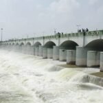
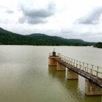
Most irrigation reservoirs are simply large bodies of stored water — Kanjirapuzha Dam’s reservoir is something more unusual: a working landscape with three islands rising from the water and a genuine commercial fishing operation run by Kerala’s Fisheries Department. Few irrigation dams manage to combine agricultural infrastructure, aquaculture, and scenic island geography quite so naturally.
Kanjirapuzha Dam: Overview
| Parameter | Details |
| State | Kerala |
| District | Palakkad |
| Nearest town | Mannarkkad |
| Distance from Mannarkkad | Approx. 13 km |
| Distance from Palakkad town | Approx. 43 km |
| River | Kanjirapuzha (Kanhirapuzha) River, a tributary of the Thuthapuzha River (itself a tributary of the Bharathapuzha) |
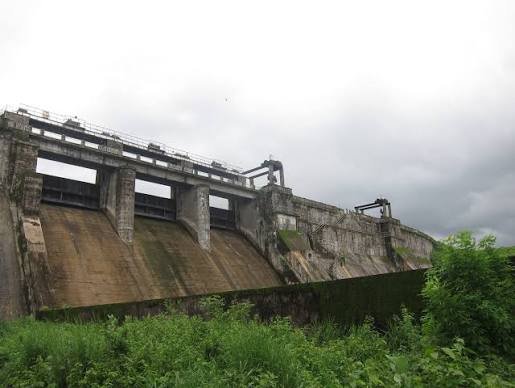
| Dam type | Earth-cum-masonry composite dam |
| Total length | Approx. 2,127–2,128 metres |
| Earthen section length | 1,896 metres, maximum height 28 metres |
| Masonry section length | 231.60 metres, maximum height 38 metres |
| Spillway | 3 spans, vertical gates |
| Construction began | 1961 |
| Year completed | 1995 |
| Initial cost estimate (1954 prices) | Rs 3.65 crore |
| Revised cost (1970 prices) | Rs 101.19 crore |
| Reservoir total capacity | 70.83 million cubic metres |
| Catchment area | 7,000 hectares, entirely within Kerala |
| Reservoir surface area | 465 hectares |
| Cultivable Command Area | 9,713 hectares |
| Taluks irrigated | Mannarkkad, Ottapalam, Palakkad |
| Notable features | Three islands within the reservoir; commercial fisheries programme |
| Catchment forest name | “Vettilachola” |
| Best time to visit | October to February |
The Kanjirapuzha River and Its Place in the Bharathapuzha System
Kanjirapuzha Dam is built across the Kanjirapuzha River, which feeds into the Thuthapuzha River, itself one of the main tributaries of the Bharathapuzha — Kerala’s second-longest river, after the Periyar. This positions Kanjirapuzha within a layered river hierarchy similar to several other Palakkad district dams, including nearby Malampuzha.
A few points about this river system:
- The dam’s entire catchment area of 7,000 hectares lies within Kerala’s state boundary, unlike some rivers whose catchments span multiple states, giving the project a relatively straightforward single-state water management context
- This catchment area is covered by dense green forest known locally as “Vettilachola,” contributing to the dam’s overall scenic character
- As part of the broader Bharathapuzha basin, Kanjirapuzha sits alongside a cluster of other Palakkad district dams — including Malampuzha, Walayar, Pothundi, and Mangalam — that collectively manage water across this historically drought-vulnerable region
A 34-Year Project With a Dramatic Cost Overrun
Kanjirapuzha’s development timeline reflects the genuine complexity of large mid-20th-century Indian irrigation projects. Construction, including the associated irrigation system, began in 1961, but the dam wasn’t fully completed and opened until 1995 — a 34-year span from start to finish.
The project’s cost escalation over this period was substantial:
- The initial cost estimate stood at Rs 3.65 crore, calculated at 1954 price levels
- By the time the project neared completion, this figure had been revised to Rs 101.19 crore at 1970 price levels — an increase reflecting both genuine construction cost inflation and the extended timeline over which the project was executed
- The irrigation command area was only partially developed by 1980, reaching a Cultivable Command Area of 8,465 hectares at that stage, before eventually expanding toward the fuller target of 9,713 hectares
This kind of extended timeline and cost escalation, while significant, is not unusual among mid-century Indian irrigation projects that spanned multiple decades of shifting economic conditions and phased construction.
Engineering Specifications: Two Materials, Two Heights
Kanjirapuzha Dam’s composite construction gives it two distinct structural sections, each with its own height and length specifications — a detail that explains why different sources sometimes cite different overall height figures for the dam.
Core specifications:
- Earthen section: 1,896 metres long, with a maximum height of 28 metres
- Masonry section: 231.60 metres long, with a maximum height of 38 metres
- Total dam length: approximately 2,127–2,128 metres
- Spillway: 3 spans fitted with vertical gates
This hybrid design, using earthen embankment for the majority of the dam’s length while reserving masonry construction for the section requiring greater structural strength, reflects a cost-effective and commonly used approach for large Kerala irrigation dams of this era.
Three Islands and a Working Fishery: What Sets This Reservoir Apart
Kanjirapuzha’s reservoir has developed a genuinely distinctive character beyond its irrigation function. Three islands rise from within the reservoir, giving the water body a visually striking, fragmented landscape rather than a single uniform expanse of water. Alongside this scenic feature, Kerala’s Fisheries Department has established a commercial fisheries development programme operating directly within the reservoir.
A few points about this combination:
- The presence of islands within an irrigation reservoir is relatively unusual among Kerala’s major dams, giving Kanjirapuzha a distinct visual identity compared to more uniform reservoirs elsewhere in the state
- The commercial fisheries programme reflects a deliberate secondary economic use of the reservoir, generating livelihood opportunities alongside the dam’s primary agricultural function
- This dual-purpose approach — irrigation infrastructure supporting an active fishing economy — illustrates how Indian dam reservoirs can be managed for more than a single stated purpose when local conditions allow
What the Dam Irrigates
Kanjirapuzha Dam’s core purpose remains agricultural irrigation, serving farmland across three taluks in Palakkad district:
- Cultivable Command Area: 9,713 hectares
- Taluks served: Mannarkkad, Ottapalam, and Palakkad
- Distribution system: right and left bank canal systems carrying water from the reservoir to agricultural land across the command area
Water releases from Kanjirapuzha have also periodically made local news — including planned release schedules communicated to farmers and downstream communities, reflecting the ongoing operational coordination required to balance reservoir levels with seasonal agricultural demand.
Planning a Visit to Kanjirapuzha Dam
For anyone considering a trip:
- Getting there: The dam sits roughly 13 km from Mannarkkad and about 43 km from Palakkad town, accessible by road
- Best season: October through February offers the most comfortable weather and typically the fullest reservoir following the monsoon
- What to see: The three islands within the reservoir and the surrounding Vettilachola forest make for a scenic visit distinct from many other Kerala dam destinations
- Combine with other Palakkad dams: Given the concentration of significant dams across Palakkad district, visitors interested in the region’s water infrastructure can combine Kanjirapuzha with nearby Malampuzha, Walayar, or Pothundi dams
FAQs
Q1. Why does Kanjirapuzha Dam have two different height measurements listed in different sources?
The dam is a composite structure with a 28-metre earthen section and a separate 38-metre masonry section, so height figures can vary depending on which section a particular source is referencing.
Q2. Is it possible to visit the islands within the Kanjirapuzha reservoir?
Access to the islands may be limited or seasonal depending on water levels and current tourism arrangements, so checking with the local irrigation department or tourism office before planning a visit specifically for island access is advisable.
Q3. Why did Kanjirapuzha Dam’s cost increase so dramatically between its initial estimate and completion?
The cost rose from Rs 3.65 crore to Rs 101.19 crore primarily due to the extended 34-year construction timeline spanning multiple decades of changing economic conditions, along with the genuine complexity of completing both the dam structure and its associated irrigation system.
Q4. Does the commercial fisheries programme at Kanjirapuzha affect the water’s use for irrigation?
The fisheries programme operates alongside the reservoir’s primary irrigation function as a managed secondary use, reflecting coordinated planning between Kerala’s Irrigation and Fisheries departments rather than any conflict between the two purposes.