Long before Jharkhand existed as a state, one of India’s most celebrated engineers put his name behind a modest earthen dam meant to solve a very specific industrial problem: keeping a coal-fired power station running without ever running dry. That engineer was Sir Mokshagundam Visvesvaraya, often called the father of Indian engineering, and the dam he helped plan — Patratu Dam — has since grown from a purely functional reservoir into one of Jharkhand’s most photographed weekend getaways.
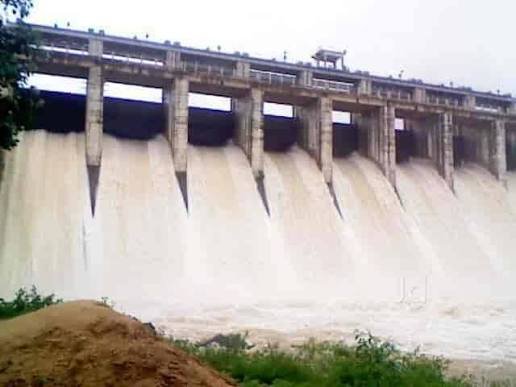
Patratu Dam Overview
| Parameter | Details |
| State | Jharkhand |
| District | Ramgarh |
| Nearest town | Patratu |
| Distance from Ranchi | Approx. 30–40 km |
| Distance from Ramgarh | Approx. 30 km |
| River | Nalkari River (also spelled Nalkarni), a tributary of the Damodar River |
| Dam type | Earth-fill dam |
| Year completed | 1960 |
| Associated with | Sir M. Visvesvaraya, planning engineer |
| Reservoir spread | Approx. 81 sq. miles (approx. 210 sq. km) |
| Area elevation | Approx. 405 metres |
| Primary purpose | Water supply to Patratu Thermal Power Station and Ramgarh cantonment |
| Secondary purpose | Irrigation for surrounding areas |
| Nearby landmark | Panchawahini Temple, an ancient religious site |
| Other facilities | Government circuit house near the dam |
| Recent development | Lake resort, adventure sports, sunset-view island |
| Popular activities | Boating, picnicking, scenic drives |
| Best time to visit | October to February |
The Nalkari River and Why This Site Was Chosen
Patratu Dam sits across the Nalkari River, a relatively modest tributary of the much larger Damodar River, which itself has long been central to industrial development across the Chota Nagpur Plateau region. The site chosen for the dam wasn’t arbitrary — the surrounding valley, fed not just by the Nalkari’s own flow but also by waterfalls cascading down from the hills that ring the area, offered a natural basin capable of holding a substantial volume of water for year-round industrial use.
This detail matters because Patratu Dam’s location decision reflects mid-20th-century India’s broader industrial priorities. The Damodar valley region was already emerging as a coal and power hub, and a dependable water source was essential infrastructure for the thermal power generation planned nearby — not a standalone irrigation or drinking-water project in the way many contemporaneous dams were.
A Dam Designed by India’s Most Celebrated Engineer
Patratu Dam’s construction, completed in 1960, is historically linked to the planning work of Sir Mokshagundam Visvesvaraya — the legendary engineer whose name is associated with major water and infrastructure projects across India, and whose birthday, 15 September, is observed nationally as Engineer’s Day. While Visvesvaraya’s most famous work predates Patratu by decades, his influence on Indian engineering planning philosophy extended into projects like this one, which prioritised practical, resource-efficient design suited to the specific industrial need it was built to serve.
A few historical points worth noting:
- The dam was purpose-built to serve the Patratu Thermal Power Station (PTPS), one of the region’s earlier major power generation facilities
- It simultaneously addressed water supply needs for the Ramgarh cantonment area, reflecting the area’s dual identity as both an industrial and military-administrative zone
- Its construction predates Jharkhand’s formation as a separate state in 2000, meaning the dam’s early administrative history sits within undivided Bihar
What the Dam Actually Feeds: Power Station and Cantonment
Unlike many Indian dams built primarily for agricultural irrigation, Patratu Dam’s core mission has always centred on industrial and institutional water supply. Two key beneficiaries define its purpose:
- Patratu Thermal Power Station (PTPS): The dam’s reservoir has historically served as the main water source keeping this coal-based power plant operational, a critical function given how water-intensive thermal power generation is
- Ramgarh cantonment area: The dam also supplies water to this military cantonment zone, underscoring its dual civilian-military significance in the region
This industrial focus explains why Patratu Dam doesn’t carry the same large-scale irrigation command area that defines many other dams profiled across India — its primary job has always been keeping a power plant and a cantonment supplied, with broader irrigation and recreational value developing more as secondary benefits over time.
Interestingly, the power station this dam was built to serve has itself evolved dramatically:
- The original Patratu Thermal Power Station, operated by the Jharkhand State Electricity Board, had an installed capacity of 840 MW, though its ageing units have in recent years operated at a fraction of that capacity
- A newer facility, the Patratu Super Thermal Power Project, developed as a joint venture between NTPC and the Jharkhand government, is being built on adjacent land, with a planned eventual capacity of 4,000 MW and current operational capacity already at 1,600 MW across two 800 MW units
- This ongoing power sector expansion in the immediate vicinity keeps Patratu Dam’s original industrial purpose relevant even as the region’s power infrastructure modernises around it
Engineering Profile and Reservoir Scale
Precise structural specifications for Patratu Dam — exact height and length figures in the way modern engineering databases record for newer dams — aren’t as widely published in accessible records, a common gap for mid-20th-century earthen dams built primarily for localised industrial use rather than as flagship multipurpose national projects. What is well documented is the scale of the reservoir the dam creates:
- The reservoir spreads across approximately 81 sq. miles (roughly 210 sq. km) when at capacity
- Water collects not just from the Nalkari River’s own channel but also from surrounding hillside waterfalls that feed into the same basin
- The surrounding elevation, averaging around 405 metres, places the dam within the characteristic plateau-and-valley terrain typical of the Chota Nagpur region
This combination of hill-fed inflow and a broad, shallow reservoir spread is part of what gives the Patratu Valley area its distinctive scenic character — winding roads cutting through hills that open onto a wide sheet of water, rather than the narrow, deep gorge-style reservoirs seen at many taller dams elsewhere in India.
From Industrial Reservoir to Jharkhand’s New Tourist Draw
For decades, Patratu Dam functioned almost entirely as utility infrastructure, known locally mainly for its role in keeping the thermal power station running. That’s changed substantially in recent years, as state and local authorities have actively developed the area into a genuine tourist destination.
Recent additions to the site include:
- A lake resort offering accommodation and dining directly overlooking the reservoir
- Adventure sports facilities, catering to visitors looking for more than a passive scenic visit
- A sunset-view island, developed specifically to give visitors an elevated vantage point for evening views across the water
- Boating facilities, now a standard draw for weekend visitors from Ranchi and Ramgarh
Alongside these newer additions, older attractions remain part of the site’s appeal:
- The Panchawahini Temple, an ancient temple adjacent to the dam holding genuine religious significance for local communities
- A government circuit house near the dam, reflecting its long administrative history
- The broader Patratu Valley, often described as the “valley of winding roads,” known for scenic drives connecting Ranchi to the dam area
This transformation mirrors a pattern seen at several older Indian irrigation and industrial dams — infrastructure originally built for a narrow utilitarian purpose gradually becoming valued just as much for recreation and tourism, sometimes decades after the fact.
Planning a Visit to Patratu Dam
For anyone considering a trip, a few practical points:
- Getting there: The dam is roughly a 30–40 km drive from Ranchi, generally under an hour by road, making it one of the more accessible day-trip destinations from Jharkhand’s capital
- Best season: October through February offers the most comfortable weather for boating and outdoor activities, along with clearer visibility for sunset views from the island viewpoint
- Combine with Patratu Valley drive: The scenic road connecting Ranchi to the dam is itself a draw, known locally for its winding hill curves and viewpoints
- Check current facility status: Since tourism infrastructure at the site has been developed relatively recently, it’s worth confirming which facilities (resort stays, adventure sports, boating) are currently operational before planning a visit around a specific activity
FAQs
Q1. Is Patratu Dam primarily a tourist site, or does it still serve its original industrial purpose?
It still serves its original purpose of supplying water to the Patratu Thermal Power Station and the Ramgarh cantonment area, even as the surrounding Patratu Valley has been developed into a popular tourist destination in recent years.
Q2. What connection does the dam have to Sir M. Visvesvaraya, and is this widely documented?
Historical records associate Patratu Dam’s construction planning with Sir M. Visvesvaraya, India’s celebrated engineer, though as with many mid-20th-century regional projects, detailed archival documentation of his specific role is less extensively published than for his more famous, larger-scale works.
Q3. Can visitors actually swim or fish in the reservoir, or is it restricted given its industrial role?
Recreational activities like boating are available through the developed tourism facilities at the site, but given the reservoir’s ongoing role supplying a thermal power station, visitors should follow posted local guidelines rather than assume unrestricted access to all parts of the water body.
Q4. Why doesn’t this dam have the detailed height and length specifications commonly listed for other major Indian dams?
As a mid-century dam built primarily for localised industrial water supply rather than as a flagship national multipurpose project, detailed engineering specifications weren’t as consistently published or digitised as they have been for larger, more prominent dams built under national river-valley programs.