Ask a birdwatcher in Pune where to spot Demoiselle Cranes flying in from Central Asia, and there’s a good chance they’ll point you toward Veer Dam rather than any wildlife sanctuary. This unassuming irrigation project on the Nira River has quietly built a second identity over the decades — as one of the best birding stretches near Pune — even though it was built for a far more practical reason: keeping farmland in two districts watered through the dry months.
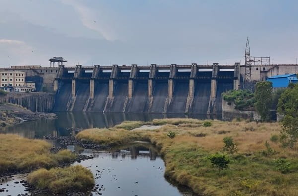
Veer Dam: Key Facts and Figures
| Parameter | Details |
| State | Maharashtra |
| Districts | Satara and Pune (dam sits on the district border) |
| Nearest village | Veer, near Shirwal |
| Taluka | Khandala (Satara side), Purandar (Pune side) |
| River | Nira River |
| Distance from Pune | Approx. 70 km |
| Distance from Satara city | Approx. 80 km |
| Dam type | Rubble-concrete gravity dam |
| Height | 35.81 m (approx. 117 ft) |
| Length | Approx. 3,629 m (approx. 3.6 km) |
| Number of gates | 9 |
| Reservoir capacity | 266 million cubic metres |
| Canals | Nira Left Canal and Nira Right Canal |
| Installed power capacity | 9 MW (2 x 4.5 MW) |
| Year completed | 1965 |
| Owner/operator | Government of Maharashtra (Water Resources Department) |
| Primary purpose | Irrigation, with hydroelectric generation |
| Notable feature | Major birdwatching site — 170+ recorded bird species |
| Best time to visit | October to February |
Where Exactly Is Veer Dam Located
Veer Dam sits in an interesting administrative spot — right on the border between two districts. The dam takes its name from Veer village, which lies at the meeting point of Khandala taluka in Satara district and Purandar taluka in Pune district. Most travel references simply describe it as being near Shirwal, a small town that acts as the practical gateway for anyone driving out from Pune.
Getting there is straightforward for anyone based in Pune city:
- The dam is roughly 70 km from Pune, generally a drive of under two hours depending on traffic through Saswad or the Pune-Bengaluru highway stretch
- From Satara city, the distance runs closer to 80 km
- The nearest well-known town, Shirwal, sits on the Pune-Satara highway corridor, making it easy to combine a Veer Dam visit with other stops along that route
Because the dam straddles a district boundary, its water and administrative benefits are shared between Pune and Satara — a detail that matters for understanding why two separate canal systems were built to serve both sides.
The Nira River Connection
The Nira River, on which this dam is built, is itself a tributary of the Bhima River, which eventually joins the larger Krishna river system. Unlike some Western Ghats rivers that carry water year-round from perennial glacial or spring sources, the Nira depends heavily on monsoon rainfall collected across its upstream catchment, which includes water released from older dams further upstream in the same river valley.
This upstream dependency is worth noting for a simple reason: Veer Dam isn’t operating in isolation. It sits downstream of other major reservoirs in the Nira basin, including Bhatghar Dam and Nira Deoghar Dam. Water management across this entire chain of dams is coordinated, meaning Veer Dam’s reservoir levels often respond directly to how much water is being released from dams further up the valley — a fact that regularly makes local news during monsoon season when multiple Nira basin dams approach full capacity together.
A Brief History of How Veer Dam Came to Be
Before the current dam existed, a smaller structure occupied roughly the same stretch of the Nira River. Older accounts describe an earlier, modest barrage near this location that held back a limited amount of water — enough for a much smaller irrigation network fed by canals drawing from water released via the older Lloyd Dam system upstream. That earlier structure held only a fraction of the storage capacity Veer Dam manages today.
Construction of the present dam was completed in 1965, and the scale-up in storage was significant — jumping from a modest few million cubic metres held by the older barrage to the 266 million cubic metres the current structure can hold. This wasn’t a random expansion. Pune and Satara’s plains needed a dependable irrigation source for the sugarcane and foodgrain belts that had developed along the Nira valley, and the older, smaller structure simply couldn’t meet growing agricultural demand.
A few historical points worth keeping in mind:
- The dam replaced an earlier, much smaller barrage on roughly the same site
- Its construction was tied to the broader Nira Valley irrigation development that also produced Bhatghar Dam and later Nira Deoghar Dam
- The project was completed under the state’s post-Independence irrigation expansion drive, similar in spirit to other large Maharashtra dam projects of that era
Engineering Specifications: How the Dam Is Built
Veer Dam is a rubble-concrete gravity dam, a construction style common across Maharashtra’s mid-20th-century irrigation projects. Unlike earthen dams, which rely on compacted soil and rock, a rubble-concrete structure uses cemented masonry blocks to resist water pressure through sheer mass and gravity — hence the term “gravity dam.”
The core specifications:
- Height: 35.81 metres (approximately 117 feet) measured from the foundation
- Length: approximately 3,629 metres, making it a fairly long structure by Maharashtra dam standards
- Gates: 9 gates control water release into the Nira riverbed downstream
- Storage capacity: 266 million cubic metres at full reservoir level
This combination of moderate height but considerable length is fairly typical for dams built across relatively flat river valleys, where engineers need to seal off a wide floodplain rather than a narrow gorge. It’s part of why Veer Dam’s reservoir spreads out gently across the landscape rather than forming a deep, narrow lake.
Irrigation Network: The Two Canals
The whole point of building Veer Dam at this scale was irrigation, and that mission runs through two canal systems that branch out from the reservoir:
- Nira Left Canal (Nira Davi Canal) — serves agricultural land primarily on one side of the river valley
- Nira Right Canal (Nira Ujwa Canal) — irrigates farmland on the opposite bank
Together, these canals support one of the more productive agricultural belts in this part of Maharashtra, known particularly for sugarcane cultivation, which requires consistent water supply through dry months. Farmers across both Pune and Satara districts depend on scheduled water releases from Veer Dam, coordinated with the broader Nira basin release schedule mentioned earlier.
Power Generation: A Secondary but Steady Function
While irrigation remains the dam’s primary job, Veer Dam also hosts a small hydroelectric power station with an installed capacity of 9 MW, split across two units of 4.5 MW each. This isn’t a large output compared to major hydro projects elsewhere in India, but it adds a useful, steady contribution to the local grid while making productive use of water that’s being released for irrigation anyway — a common secondary function built into many mid-sized Indian irrigation dams.
Why Birdwatchers Know This Dam Better Than Most Tourists Do
Here’s what genuinely sets Veer Dam apart from dozens of similar irrigation dams across Maharashtra: the 7-8 km stretch along the Nira River near the dam has become one of the richest birding corridors close to Pune. Over 170 species have been recorded in this belt, and the variety is what draws serious birders rather than casual visitors.
Species regularly spotted here include:
- Bar-headed Geese — high-altitude migrants that fly in from Central Asia and Tibet during winter
- Demoiselle Cranes — another long-distance winter migrant known for its striking grey plumage
- A wide range of waders feeding along the shallow reservoir edges
- Raptors patrolling the open agricultural land surrounding the reservoir
- Flycatchers and other passerines in the vegetation lining the riverbank
This makes Veer Dam functionally different from most entries in typical “dam guide” content — it’s less a scenic tourist stop and more a working birding site that rewards patience and early-morning visits, particularly between October and February when winter migrants are present in the largest numbers.
Planning a Visit
A few practical points for anyone considering a trip out to Veer Dam:
- Best season: October through February, both for pleasant weather and peak migratory bird activity
- Early mornings work best, especially for birdwatching, when bird activity along the reservoir edge is highest
- Carry binoculars and a good zoom lens if birding is the goal — the reservoir’s open water and exposed banks mean birds are often visible at a distance rather than up close
- Combine with Shirwal or the Pune-Satara highway route if travelling from Pune, since the dam sits just off this corridor
- Check with local sources on water release schedules during monsoon months, since heavy releases from upstream dams can affect water levels and access near the dam
FAQs
Q. Is Veer Dam open for general tourist visits, or is it restricted?
The dam and its surrounding reservoir area are generally accessible to visitors, though core dam infrastructure like the gate control areas typically falls under restricted access managed by the state irrigation department.
Q. Why does Veer Dam sit on the border of two districts instead of within just one?
The Nira River itself forms a natural boundary in this stretch, with Khandala taluka of Satara district on one side and Purandar taluka of Pune district on the other, so the dam and its benefits were designed to serve both sides.
Q. Is Veer Dam connected to other dams on the Nira River, or does it operate independently?
It operates as part of a coordinated chain of dams in the Nira basin, including Bhatghar and Nira Deoghar dams upstream, meaning its water levels are influenced by release decisions made further up the valley.
Q. What’s the best way to see the migratory birds without disturbing them?
Visiting during early morning hours in the winter months, staying along the accessible banks rather than approaching the water’s edge directly, and using binoculars or a zoom lens instead of walking closer generally gives the best sightings with minimal disturbance.