Feasibility studies for this dam began in 1953 — but the project sat stalled for years because of an unresolved water-sharing dispute with Pakistan. It took the 1960 Indus Waters Treaty, which finally granted India exclusive rights over the Ravi River, to unlock construction. Even then, it took until 2001 for Ranjit Sagar Dam to be fully completed, closing a genuinely extraordinary 48-year gap between initial concept and finished project.
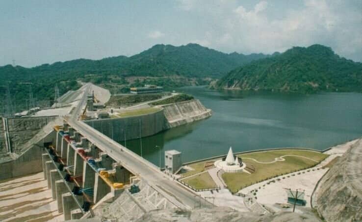
Ranjit Sagar Dam: Overview
| Parameter | Details |
| State | Punjab, on the border with Jammu and Kashmir |
| Location | Shahpurkandi, Basholi area, Pathankot district |
| Distance from Pathankot | Approx. 17–30 km |
| Distance from Pakistan border | Approx. 24 km |
| Also known as | Thein Dam |
| Named after | Maharaja Ranjit Singh, founder of the Sikh Empire |
| River | Ravi River |
| Dam type | Earth-fill embankment |
| Height | 160 metres (525 ft) — among India’s highest earth-fill dams |
| Length | 617 metres (2,024 ft) |
| Reservoir total capacity | 3.28 billion cubic metres |
| Reservoir territorial split | Approx. 60% of the reservoir lies within Jammu and Kashmir |
| Feasibility study began | 1953 |
| Construction began | 1981 |
| Dam structure completed | 1998 |
| Generators commissioned | 2000 |
| Full project completed | March 2001 |
| Operator | Department of Water Resources, Government of Punjab |
| Installed power capacity | 600 MW (4 x 150 MW turbines) — largest hydroelectric dam in Punjab |
| Downstream companion project | Shahpurkandi Dam |
| Best time to visit | August to September, when the reservoir is fullest |
The Ravi River and a Border That Splits the Reservoir
Ranjit Sagar Dam sits across the Ravi River at a location that straddles the border between Punjab and Jammu and Kashmir, positioned upstream of the Madhopur Barrage. This border-straddling location creates a genuinely unusual territorial arrangement: while the dam itself is operated entirely by Punjab’s Department of Water Resources, roughly 60% of the reservoir’s actual surface area falls within Jammu and Kashmir territory.
A few points about this positioning:
- The dam sits almost exactly equidistant from Pathankot in Punjab and Kathua in Jammu and Kashmir, both roughly 30 km away
- Its location just 24 km from the international border with Pakistan places it within a genuinely strategic stretch of northwestern India
- Unlike the nearby Bhakra and Pong dams, which are managed by the interstate Bhakra Beas Management Board, Ranjit Sagar Dam operates entirely under Punjab’s own control — a notable difference in governance structure despite the reservoir’s substantial presence within neighbouring J&K territory
Half a Century in the Making: History
Ranjit Sagar Dam’s development timeline is genuinely extraordinary, spanning nearly five decades from initial concept to full completion. Feasibility studies began as early as 1953, but the project’s progress was significantly complicated by an unresolved water-sharing dispute with Pakistan over the Ravi River’s flow.
The turning point came with the 1960 Indus Waters Treaty, which granted India exclusive rights over the water of the Ravi, along with the Beas and Sutlej — the three “eastern rivers” under that treaty’s framework. This resolution finally allowed the Punjab government to move forward with a scheme for optimal utilisation of the river’s water.
Even after this, the path to completion remained lengthy:
- Geo-technical studies continued for another two decades, concluding around 1980
- Actual construction work began in 1981
- The dam structure itself was completed in 1998, at a total cost of approximately Rs 6,800 crore
- The dam remained underutilised for a period afterward, since the Shahpur Kandi Project, originally conceived as part of the same broader scheme, was needed to fully house the power generation component
- Generators were finally commissioned in 2000, with the complete project reaching full operational status by March 2001
This nearly half-century journey — from a 1953 feasibility study, through an international treaty resolution, to a 2001 completion — makes Ranjit Sagar Dam one of the more genuinely protracted major Indian infrastructure undertakings, its timeline shaped as much by international diplomacy as by domestic engineering challenges.
Engineering Specifications
Ranjit Sagar Dam is built as an earth-fill embankment structure, standing 160 metres (525 ft) tall and stretching 617 metres (2,024 ft) in length, with a crest width of 14 metres and a substantial base width of 669.2 metres.
Core specifications:
- Height: 160 metres (525 ft) — one of the highest earth-fill dams in India
- Length: 617 metres (2,024 ft)
- Dam volume: 21.92 million cubic metres
- Spillway: controlled-chute type, discharge capacity of 24,637 cubic metres per second
- Reservoir total capacity: 3.28 billion cubic metres
- Reservoir active capacity: 2.344 billion cubic metres
The dam also holds the distinction of housing the largest-diameter penstock pipes anywhere in India, a genuinely notable engineering feature reflecting the scale of water flow the project was designed to channel toward its power generation turbines.
Power Generation and Flood Control
Ranjit Sagar Dam’s power station, commissioned in 2000, houses four 150 MW Francis-type turbines for a combined installed capacity of 600 MW, making it the largest hydroelectric project in the state of Punjab.
Beyond power generation, the dam serves a significant flood-control function for the surrounding region:
- The undulating, sub-mountainous terrain of this area, combined with numerous seasonal streams, historically produced frequent flash floods during the monsoon season
- The dam’s reservoir capacity has substantially reduced this flood risk, channelling water for controlled irrigation and power generation use rather than allowing unregulated seasonal flooding
- This flood-moderation benefit extends across a wide stretch of Punjab’s border region with Jammu and Kashmir, making the dam significant for community safety as well as agricultural and industrial water use
A Downstream Companion: Shahpurkandi Dam and Coordinated Flood Management
Ranjit Sagar Dam doesn’t operate in isolation. A downstream companion project, the Shahpurkandi Dam, sits roughly 11 km below Ranjit Sagar and about 8 km above Madhopur, designed specifically to irrigate 5,000 hectares in Punjab and a substantially larger 32,000 hectares in Jammu and Kashmir.
A few points about this related project and recent developments:
- Construction on Shahpurkandi Dam began in 2014, but the project faced decades of delay before its civil works were finally completed in early 2024
- The project includes two powerhouses with a combined installed capacity of 206 MW (6 x 33 MW plus 1 x 8 MW Kaplan-type turbines)
- Power component commissioning was targeted for mid-September 2025, subject to safety clearances, according to the most recent available information
- A significant flood event on the Ravi in 2025 highlighted the need for tighter, coordinated operating protocols across the Ranjit Sagar, Shahpurkandi, and Madhopur systems, including shared situational awareness between operators and pre-agreed Emergency Action Plans binding all three structures to act as a single coordinated system
Given that this situation continues to evolve, readers seeking the very latest status of Shahpurkandi Dam’s commissioning or any updated flood-management coordination protocols should check current news sources for the most recent developments.
Planning a Visit to Ranjit Sagar Dam
For anyone considering a trip:
- Getting there: The dam sits roughly 17–30 km from Pathankot city, accessible by road
- Best season: August or September offers the fullest reservoir and most scenic views, following the peak monsoon period
- What to see: The dam’s lush green surroundings and serene, idyllic setting make it a genuinely popular picnic and scenic destination
- Security considerations: Given its proximity to the international border and its status as significant strategic infrastructure, visitors should expect standard security protocols in the area
FAQs
Q1. Why did it take nearly 50 years to complete Ranjit Sagar Dam?
The project’s early feasibility studies stalled due to an unresolved water-sharing dispute with Pakistan, only unlocked after the 1960 Indus Waters Treaty granted India exclusive rights over the Ravi River, and even after this resolution, extended geo-technical studies and phased construction meant the dam wasn’t fully completed until 2001.
Q2. Why does most of the reservoir sit in Jammu and Kashmir even though Punjab operates the dam?
This reflects the dam’s location directly on the Punjab-Jammu and Kashmir border, where the natural topography means the reservoir’s water spreads predominantly into J&K territory even though the dam structure itself and its management fall under Punjab’s Department of Water Resources.
Q3. Is Ranjit Sagar Dam connected to the Shahpurkandi Dam, and does one affect the other’s operation?
Yes — Shahpurkandi Dam sits just downstream of Ranjit Sagar and works in coordination with it, and recent flood events have specifically highlighted the need for tighter operational coordination between the two structures and the further downstream Madhopur system.
Q4. Why is Ranjit Sagar Dam managed differently from nearby dams like Bhakra and Pong?
Unlike Bhakra and Pong, which are managed by the interstate Bhakra Beas Management Board, Ranjit Sagar Dam operates entirely under the control of Punjab’s own Department of Water Resources, reflecting a different governance structure despite its significant presence within neighbouring Jammu and Kashmir territory.