
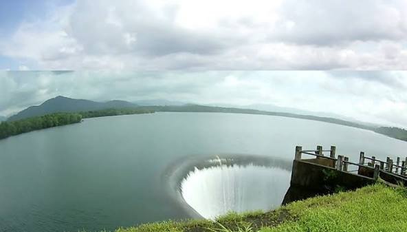
Every tap in South Goa’s beach resorts, restaurants, and homes traces back to a single reservoir most tourists have never heard of. Salaulim Dam, Goa’s largest manmade water storage body, quietly supplies the drinking water that keeps the state’s massive tourism economy running — and during peak monsoon, its distinctive funnel-shaped spillway turns into one of the more dramatic engineering spectacles in South Goa.
Salaulim Dam: Overview
| Parameter | Details |
| State | Goa |
| District | South Goa |
| Taluka | Sanguem |
| Location | Sirga, approx. 5 km from Sanguem town |
| Distance from Margao | Approx. 26 km |
| River | Salaulim (Selaulim) River, a tributary of the Zuari River |
| Dam type | Composite earth-cum-masonry (earth-fill and gravity) |
| Height | 42.7 metres (140 ft) |
| Length | 1,004 metres (3,294 ft) |
| Spillway | One, concrete duckbill (Morning Glory) type, 44 metres long |
| Project approved | 1971, original cost estimate Rs 9.61 crore |
| Construction began | 1975–1976 |
| Year completed | 2000 |
| Revised cost estimate (2007) | Approx. Rs 170 crore |
| Owner | Goa Water Resources Department |
| Reservoir water spread area | 24 sq. km — Goa’s largest manmade reservoir |
| Catchment area | 227 sq. km |
| Irrigation potential | Up to 14,326 hectares (35,400 acres) |
| Drinking/industrial water supply | 380 MLD to South Goa |
| Nearby protected area | Netravali Wildlife Sanctuary |
| Best time to visit | Just after the monsoon, October to December |
The Salaulim River and Goa’s Largest River System
Salaulim Dam is built across the Salaulim River (also spelled Selaulim, and known locally in places as the Sanguem river), a tributary feeding into the Zuari River — the largest river in Goa, stretching 92 km and forming a critical part of the state’s tidal river network. The Zuari itself takes shape specifically at the confluence of the Selaulim and Uguem rivers within Sanguem taluk, meaning Salaulim Dam sits right at the headwaters of Goa’s most significant waterway.
A few points about this river system:
- The Zuari flows in a south-westerly direction through the talukas of Tiswadi, Ponda, Mormugao, Salcete, Sanguem, and Quepem before reaching the Arabian Sea
- Other tributaries feeding the broader Zuari system include the Kushawati and Guleli rivers, giving the basin a genuinely complex network of smaller streams
- Salaulim Dam’s catchment of 227 sq. km captures monsoon runoff from the surrounding Western Ghats foothills, an area of substantial rainfall even by Goa’s already monsoon-heavy standards
History: A Three-Decade, Cost-Escalating Project
Salaulim Dam’s journey from approval to completion stretched across nearly three decades, accompanied by a dramatic escalation in project costs. The project was formally approved in 1971, with an original estimated cost of just Rs 9.61 crore. Construction, however, didn’t begin until 1975–1976, and the dam wasn’t completed until 2000 — nearly a quarter-century after construction started, and almost 30 years after the project’s original approval.
A few points about this extended timeline and cost growth:
- By 2007, the project’s estimated cost had risen to approximately Rs 170 crore, representing roughly an 18-fold increase from the original 1971 estimate
- Even after the dam’s 2000 completion, the associated irrigation component remained in its final stages as of 2007, having achieved an irrigation potential of 9,537 hectares against the project’s ultimate target of 14,326 hectares
- This pattern — a completed dam structure followed by a separately lagging irrigation network — reflects a common challenge seen at several Indian dam projects, where the primary structure’s completion doesn’t automatically mean the full benefit delivery system is finished at the same time
Engineering Specifications: A Distinctive Duckbill Spillway
Salaulim Dam is built as a composite earth-cum-masonry structure, standing 42.7 metres (140 ft) tall and stretching 1,004 metres (3,294 ft) in length. Its most visually distinctive engineering feature is its spillway design — a concrete duckbill, or Morning Glory type, spillway measuring 44 metres in length.
Core specifications:
- Height: 42.7 metres (140 ft)
- Length: 1,004 metres (3,294 ft)
- Spillway type: Duckbill (Morning Glory), concrete, 44 metres long
- Reservoir capacity: approximately 227–234 million cubic metres of live storage
- Water spread area: 24 sq. km, the largest of any manmade reservoir in Goa
A duckbill or Morning Glory spillway is a distinctive funnel-shaped overflow structure, relatively uncommon compared to the more typical straight or radial-gated spillways found at most Indian dams, and it gives Salaulim a genuinely unique visual character during periods of high water flow.
What the Dam Supplies: South Goa’s Drinking Water Lifeline
Salaulim Dam’s core purpose has expanded considerably since its original conception. The project was initially designed to supply 160 million litres per day (MLD) of drinking water to South Goa, alongside its irrigation mandate covering up to 14,326 hectares of farmland.
Given the sheer scale of Goa’s growth as a tourism destination in the decades since the dam’s approval, this water supply component has since been significantly expanded:
- Current drinking and industrial water supply: 380 MLD, more than double the originally planned figure
- Irrigation coverage: progressing toward the full 14,326-hectare target, with 9,537 hectares achieved as of 2007
- Primary beneficiary region: South Goa, encompassing the district’s growing residential, commercial, and tourism infrastructure
This scale of water supply makes Salaulim Dam genuinely foundational to South Goa’s ability to support its massive tourism economy, even though most visitors to Goa’s beaches never see or hear about the reservoir supplying their hotel showers and restaurant kitchens.
A Dramatic Monsoon Spectacle
Beyond its utilitarian function, Salaulim Dam has become a genuine visual attraction, particularly during and just after peak monsoon season, when the reservoir’s water level rises enough to overflow through the distinctive duckbill spillway.
Visitors describe this overflow as a genuinely striking spectacle:
- Water cascades through the semi-circular duckbill outlet, dropping roughly 50 feet before striking further down
- The flow then continues into a chasm reportedly around 100 feet deep, creating a dramatic, waterfall-like cascade as it strikes the riverbed below
- This combination of engineering function and visual drama makes peak monsoon overflow periods a particularly popular time for photography, even though water levels and general accessibility can vary considerably with rainfall intensity
Nearby: Netravali Wildlife Sanctuary
Salaulim Dam’s location places it close to the Netravali Wildlife Sanctuary, adding a genuine ecological dimension to any visit focused primarily on the dam itself. This proximity allows visitors interested in Goa’s Western Ghats biodiversity to combine a dam visit with broader wildlife and nature exploration in the same general trip, extending beyond the dam’s purely functional water-supply role.
Planning a Visit to Salaulim Dam
For anyone considering a trip:
- Getting there: The dam sits at Sirga, roughly 5 km from Sanguem town and about 26 km from Margao, accessible by road
- Best season: Visiting just after the monsoon, from October through December, offers the best chance of seeing the reservoir at its fullest, potentially including spillway overflow if water levels remain high
- What to see: The distinctive duckbill spillway, the vast reservoir surrounded by lush Western Ghats hills, and the option to combine with Netravali Wildlife Sanctuary nearby
- What to expect: A quieter, less commercialised destination compared to Goa’s beach-focused tourist circuit, appealing to visitors interested in the state’s inland natural and infrastructural landscape
FAQs
Q1. Is Salaulim Dam actually connected to Goa’s beach tourism industry, even though it’s far from the coast?
Yes, indirectly but significantly — the dam supplies 380 MLD of drinking and industrial water to South Goa, meaning much of the water used by hotels, restaurants, and residential areas across the region’s tourism-heavy districts ultimately originates from this reservoir.
Q2. Why did Salaulim Dam’s construction cost increase so dramatically between 1971 and 2007?
The project’s cost rose from an original 1971 estimate of Rs 9.61 crore to approximately Rs 170 crore by 2007, reflecting the genuine complexity of a construction timeline stretching across roughly three decades, spanning multiple economic and inflationary periods.
Q3. What makes the spillway at Salaulim Dam different from spillways at most other Indian dams?
Its duckbill (Morning Glory) design uses a distinctive funnel-shaped overflow structure rather than the more common straight or radial-gated spillway designs found elsewhere, creating a genuinely dramatic cascading water effect during periods of high overflow.
Q4. Is the irrigation component of the Salaulim project fully complete today, or is it still in progress?
As of the most recent detailed reporting available, the irrigation network was nearing but had not yet reached its full 14,326-hectare target, having achieved 9,537 hectares by 2007, so anyone researching its current full completion status should confirm the latest figures with Goa’s Water Resources Department.


