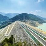
Few dams anywhere in India sit this close to genuine religious and ecological significance simultaneously. Srisailam Dam rises barely 1.6 km downstream from a temple that holds the rare distinction of being both a Jyotirlinga and a Shakti Peetha — two of Hinduism’s most sacred site classifications combined in a single shrine — while the surrounding forest forms part of India’s largest tiger reserve, spanning over 3,000 sq. km of Nallamala wilderness.

Srisailam Dam: Overview
| Parameter | Details |
| States | Andhra Pradesh (Nandyal district) and Telangana (Nagarkurnool district) |
| Location | Nallamala Hills, near Srisailam temple town |
| Distance from Hyderabad | Approx. 245 km |
| River | Krishna River |
| Dam type | Gravity and masonry |
| Height | 145.10 metres (476 ft) |
| Length | 512 metres (1,680 ft) |
| Construction began | 1960 |
| Year completed | 1981 |
| Construction cost | Grew from an initial ₹384.7 million estimate to over ₹10 billion |
| Spillway | 12 radial crest gates, capacity 38,369 cubic metres/second |
| Reservoir | Srisailam Reservoir (Neelam Sanjeevareddy Sagar) |
| Reservoir total capacity | 216 TMC ft (6.1 cubic km) |
| Reservoir surface area | 616 sq. km |
| Installed power capacity | 1,670 MW — India’s 2nd largest hydroelectric station by capacity |
| Villages submerged | Approx. 102, across Kurnool and Nagarkurnool districts |
| Irrigation coverage | Approx. 2,000 sq. km overall |
| Nearby temple | Bramaramba Mallikarjuna Temple — a Jyotirlinga and Shakti Peetha |
| Surrounding protected area | Nagarjunasagar-Srisailam Tiger Reserve (3,296 sq. km) — India’s largest |
| Best time to visit | November to February |
The Krishna River Through a Gorge in the Nallamala Hills
Srisailam Dam is built across the Krishna River at a point where the river cuts through a deep gorge in the thickly wooded Nallamala Hills, straddling the border between Nandyal district in Andhra Pradesh and Nagarkurnool district in Telangana. This gorge setting, at an elevation of roughly 300 metres, gave engineers a naturally favourable site for a tall gravity structure.
A few points about this location:
- The Krishna’s massive catchment feeding this dam spans 206,040 sq. km, reflecting the river’s status as one of peninsular India’s largest waterways
- The dam’s position within a designated tiger reserve and beside a major pilgrimage site gives it a genuinely unusual combination of infrastructural, ecological, and religious significance concentrated in one relatively compact geographic area
- Downstream, excess water beyond what’s needed to maintain Srisailam Reservoir flows onward into the Nagarjunasagar Reservoir, where it contributes to further hydroelectric generation — a sequential cascade relationship between two of the Krishna’s most significant dams
History: From a Power-Only Project to a 20-Year Multipurpose Undertaking
Srisailam Dam’s construction began in 1960 and took more than two decades to complete, with the dam finally becoming operational in 1981. Its original conception was considerably narrower than what was eventually built.
A few historical points worth understanding:
- The project began as a power-only initiative, with an initial cost estimate of just ₹384.7 million
- Over the following two decades, the project was substantially expanded into a genuine multipurpose facility incorporating irrigation and water supply alongside power generation, pushing the total cost beyond ₹10 billion by completion
- Construction displaced residents from approximately 102 villages across both Kurnool (now including parts of Nandyal) and Nagarkurnool districts, reflecting the substantial submergence footprint required to create the dam’s 616 sq. km reservoir
This trajectory — from a modest single-purpose power project to a vastly expanded, multi-decade multipurpose undertaking — reflects a pattern seen at several major Indian dams of this era, where initial engineering ambitions grew substantially as planners recognised the broader regional water security potential of a single large storage structure.
Engineering Specifications
Srisailam Dam is built as a gravity and masonry structure, with height figures reported between 145 and 241 metres depending on the specific measurement reference used (foundation versus riverbed), and a consistently cited length of 512 metres (1,680 ft).
Core specifications:
- Height: 145.10 metres (476 ft), by the most commonly cited measurement
- Length: 512 metres (1,680 ft)
- Spillway: 12 radial crest gates, discharge capacity of 38,369 cubic metres per second
- Reservoir total capacity: 216 TMC ft (6.1 cubic km)
- Reservoir surface area: 616 sq. km
This substantial spillway capacity reflects the scale of flood management required given the Krishna’s massive catchment area feeding into this single gorge-constrained reservoir.
India’s Second-Largest Hydroelectric Station
Srisailam Dam’s power station ranks as India’s second-largest hydroelectric facility by installed capacity, generating a combined 1,670 MW split across two separately operated banks:
- Left bank (Telangana, operated by TSGENCO): 6 x 150 MW reversible Francis-type turbines, totalling 900 MW
- Right bank (Andhra Pradesh, operated by APGENCO): 7 x 110 MW Francis-type turbines, totalling 770 MW
This split operational structure — with the two neighbouring states each managing their own bank of the same physical dam — reflects the post-2014 bifurcation of Andhra Pradesh into Andhra Pradesh and Telangana, requiring coordinated but administratively separate management of a single shared piece of critical infrastructure.
Beyond power generation, the dam’s irrigation network extends across approximately 2,000 sq. km, with the right bank branch canal alone providing assured irrigation to roughly 790 sq. km of farmland across Kurnool and Kadapa districts.
A Dam Beside One of Hinduism’s Rarest Dual Sacred Sites
Perhaps Srisailam Dam’s most distinctive feature isn’t engineering at all — it’s the temple sitting just 1.6 km upstream at the Patalganga ghat. The Bramaramba Mallikarjuna Temple holds a genuinely rare dual religious classification: it is one of the twelve Jyotirlingas dedicated to Lord Shiva (as Mallikarjuna Swamy) and simultaneously one of the eighteen Shakti Peethas dedicated to the goddess (as Bramaramba), making it significant to both the Shaivism and Shaktism traditions of Hinduism at once.
A few points about this religious context:
- This combination of Jyotirlinga and Shakti Peetha status at a single site is genuinely uncommon, and Srisailam is one of the very few locations in India holding both classifications simultaneously
- The temple town maintains a strict traditional dress code, requiring conventional Hindu attire and prohibiting modern or revealing clothing to preserve the site’s sanctity
- Patalganga, the scenic spot near the temple on the banks of the Krishna, offers boat rides giving visitors a unique water-level perspective of the dam itself, combining pilgrimage and dam sightseeing naturally within the same visit
Inside India’s Largest Tiger Reserve
Srisailam Dam sits within the Nagarjunasagar-Srisailam Tiger Reserve, spanning 3,296 sq. km of dry mixed deciduous forest across the Nallamala Hills — widely cited as India’s largest tiger reserve by area. This designation gives the dam’s surroundings genuine ecological significance well beyond its function as water and power infrastructure.
A few points about this protected landscape:
- The reserve serves as critical habitat for tigers, leopards, and a wide range of other Nallamala Hills flora and fauna
- This combination of a major hydroelectric project operating within India’s largest tiger reserve represents a genuinely significant case of infrastructure and wildlife conservation coexisting at scale
- Visitors interested in wildlife, alongside the dam and temple, can explore this dimension of the broader Srisailam region, though formal tiger reserve visits typically require separate permits and guided access through forest department channels
Planning a Visit to Srisailam Dam
For anyone considering a trip:
- Getting there: The dam sits roughly 245 km from Hyderabad and 132 km from Nandyal, accessible by road
- Best season: November through February offers the most comfortable weather for visiting this hilly, forested region
- What to see: Combine dam viewing with a visit to the Bramaramba Mallikarjuna Temple, a boat ride at Patalganga, and — with appropriate permits — exploration of the surrounding tiger reserve
- Respect local customs: Given the temple’s strict traditional dress code, visitors planning to combine dam sightseeing with temple visits should dress appropriately in advance
FAQs
Q1. Why does Srisailam Dam have different height figures reported across various sources?
This reflects different measurement reference points — some sources measure height from the riverbed while others measure from the deepest foundation level, producing figures ranging from approximately 145 metres to as high as 241 metres depending on which standard is used.
Q2. Is it true that the temple near Srisailam Dam holds two different types of sacred status simultaneously?
Yes — the Bramaramba Mallikarjuna Temple is genuinely unusual in being classified as both one of the twelve Jyotirlingas of Lord Shiva and one of the eighteen Shakti Peethas of the goddess, a dual religious significance held by very few sites in India.
Q3. Can visitors see tigers at Srisailam given its location within India’s largest tiger reserve?
Tiger sightings are never guaranteed given the reserve’s vast size and the animals’ naturally elusive behaviour, and formal wildlife viewing typically requires separate permits and guided access arranged through forest department channels rather than casual exploration during a dam or temple visit.
Q4. Why is Srisailam Dam’s power station operated separately by two different states?
This reflects the 2014 bifurcation of the former Andhra Pradesh into Andhra Pradesh and Telangana, with the dam’s left bank power generation now managed by Telangana’s TSGENCO and the right bank by Andhra Pradesh’s APGENCO, even though the underlying dam structure remains a single shared piece of infrastructure.