Every year on 31 July, a group of people gather in Dehradun to relive memories of a town that no longer exists. Old Tehri, once the cultural and political heart of Garhwal, disappeared beneath the waters of India’s tallest dam in 2004, its last tunnel sealed shut after decades of protest that included a 45-day hunger strike by one of India’s most revered environmentalists, Sunderlal Bahuguna.
Tehri Dam: Overview
| Parameter | Details |
| State | Uttarakhand |
| District | Tehri Garhwal |
| River | Bhagirathi River, a headstream of the Ganga |
| Dam type | Earth and rockfill embankment |
| Height | 260.5 metres — India’s tallest dam |
| Conceptual origins | 1940s (first taken up 1949) |
| Formal government sanction | 1972 |
| Construction began | 1978 |
| Year completed | 2006 |
| Managing body | Tehri Hydro Development Corporation (THDC), formed 1988 |
| People displaced | Approx. 100,000, from over 100 villages |
| Villages fully submerged | 37 |
| Old Tehri submerged | 31 July 2004 |
| Replacement settlement | New Tehri, built on higher ground |
| Key opposition leader | Sunderlal Bahuguna, also of the Chipko Movement |
| Seismic classification | Central Himalayan Seismic Gap, Seismic Zone IV |
| Design earthquake resistance | Magnitude 8.4–8.5 (per project proponents) |
| Installed power capacity | 1,000 MW (4 x 250 MW units) |
| Best time to visit | March to June, September to November |
The Bhagirathi River and the Tallest Dam in India
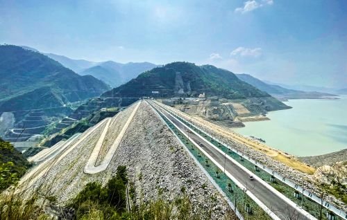
Tehri Dam is built across the Bhagirathi River, one of the two principal headstreams of the Ganga, in the Outer Himalaya of Tehri Garhwal district. At 260.5 metres, it stands as India’s tallest dam and ranks among the tallest in Asia, an earth and rockfill embankment structure chosen specifically for its ability to accommodate the region’s challenging seismic and geological conditions.
A few points about this river and setting:
- The Bhagirathi’s headwaters trace back to the Gangotri glacier, meaning Tehri Dam captures water relatively early in the Ganga system’s journey, well before the river’s more famous lower stretches
- The dam’s location in the Outer Himalaya places it within genuinely young, tectonically active mountain terrain, a factor that would come to define much of the project’s later controversy
- Its massive reservoir, stretching across the submerged Bhagirathi valley, created one of the largest artificial lakes in the Himalayan region
History: From a 1940s Idea to a Post-Soviet Funding Crisis
Tehri Dam’s origins stretch back to 1949, when the project was first taken up, though preliminary geological and hydrological investigations weren’t completed until 1961. Formal government sanction followed in 1972, and construction finally began in 1978 — nearly three decades after the idea was first proposed.
The project’s execution faced a genuinely unusual geopolitical disruption partway through:
- Soviet technical and financial support had been integral to the project’s early construction phases
- This support evaporated entirely following the dissolution of the USSR in 1991, forcing India to pivot toward domestic resources and joint ventures to keep the project moving forward
- Combined with the seismically active Himalayan terrain requiring extensive geological reassessment and design modifications, this funding disruption contributed significantly to the project’s extended timeline
- The dam was finally completed in 2006, with its four 250 MW power units phased onto the national grid between July 2006 and March 2007 — a full 57 years after the project was first conceived
The Jal Samadhi: How Old Tehri Disappeared Forever
Old Tehri wasn’t just another village — it was the historic capital of the former princely state of Tehri Garhwal, considered the cultural, political, and spiritual heart of the wider Garhwal region. As dam construction progressed through the early 2000s, the town’s fate became increasingly inevitable.
Between 2002 and 2006, residents began leaving their ancestral homes, including Sunderlal Bahuguna himself, relocating to New Tehri, a settlement built on higher ground specifically for this rehabilitation. Locals came to describe this slow process using the term “Jal Samadhi” — a water burial — as tunnel after tunnel closed, allowing the reservoir to rise:
- On 31 July 2004, the final tunnel was sealed, and Old Tehri submerged entirely beneath the rising waters
- The town had been approaching its bicentenary, a milestone it would never reach, having given way instead to the dam’s development
- Rehabilitation for displaced residents has been criticised by civil society groups as slow and incomplete, a grievance echoed at several other major Indian dam displacement stories
- Former residents continue to gather annually in Dehradun on 31 July, relieving memories of the city that once stood where the reservoir now sits — a genuinely poignant, ongoing act of collective remembrance nearly two decades after the submergence
Sunderlal Bahuguna and Decades of Resistance
Opposition to Tehri Dam was led for decades by Sunderlal Bahuguna, an environmental activist already nationally prominent for his role in the Chipko Movement, which had organised villagers to physically embrace trees to prevent deforestation. Bahuguna brought this same philosophy of committed, non-violent resistance to the fight against Tehri Dam.
Key moments in this sustained opposition:
- On 14 December 1991, hundreds of protesters occupied the dam site itself, successfully halting construction work for 75 days
- Bahuguna undertook a 45-day fast unto death, a level of personal sacrifice significant enough that it compelled the Prime Minister to formally review the project and declare a temporary moratorium on blasting
- Despite this remarkable moment of leverage, construction ultimately resumed, and the project proceeded to completion over the following fifteen years
- Some critics of the project have referred to it as “Kamdhenu” — the mythical wish-fulfilling cow of Hindu tradition — a pointed characterisation reflecting how contractors, transporters, and politicians involved in the prolonged construction all benefited financially from the project’s extended timeline
Despite the scale and duration of this opposition movement, later analysis has noted that Tehri Dam received notably little attention in the World Commission on Dams’ influential report — a gap some observers have found striking given how central the project became to India’s broader anti-dam movement discourse.
A Standing Safety Debate: Seismic Risk in the Himalaya
Tehri Dam’s location within the Central Himalayan Seismic Gap remains one of the most persistent points of technical debate surrounding the project. This tectonically active zone has experienced significant seismic events during the dam’s own construction and operational history:
- The October 1991 Uttarkashi earthquake, measuring 6.8 magnitude, struck with an epicentre just 53 km from the dam site
- The 1999 Chamoli earthquake renewed similar concerns about the region’s seismic vulnerability
- Dam proponents maintain that the structure was specifically designed to withstand an earthquake of magnitude 8.4 to 8.5
- Some seismologists, however, have suggested that earthquakes of magnitude 8.5 or greater remain genuinely possible in this region, raising questions about whether the dam’s design margins are sufficient
If a catastrophic failure were ever to occur, the potential downstream impact would be severe — populations in towns along the Bhagirathi and Ganga downstream of the dam total nearly half a million people. This risk assessment remains a subject of ongoing technical and scientific discussion rather than a settled matter, and readers with specific interest in current seismic safety assessments should consult recent geological survey reports for the most up-to-date evaluation.
Engineering Specifications and Power Generation
Tehri Dam stands 260.5 metres tall, built as an earth and rockfill embankment structure — a design choice specifically suited to withstanding seismic stress better than a rigid concrete gravity structure would in this tectonically active zone.
Its power station houses four 250 MW units, providing a combined installed capacity of 1,000 MW, synchronised to the national grid in phases between July 2006 and March 2007. Beyond power generation, the dam also serves irrigation and drinking water supply functions, with its water reaching as far as Delhi through the broader Ganga water distribution network.
Planning a Visit to Tehri Dam
For anyone considering a trip:
- Getting there: The dam sits within Tehri Garhwal district, accessible by road from major Uttarakhand towns and from Rishikesh or Dehradun
- Best season: March through June and September through November offer the most comfortable weather for visiting this Himalayan region
- What to see: Tehri Lake, the reservoir created by the dam, has become a significant destination for water sports and paragliding around the surrounding hills
- Historical reflection: Visitors interested in Old Tehri’s history may find genuine value in learning about the town’s submergence before visiting, given how central this loss remains to the region’s collective memory
FAQs
Q1. Is Tehri Dam actually safe given its location in an earthquake-prone zone?
The dam was specifically engineered to withstand an earthquake of magnitude 8.4 to 8.5 according to its designers, though some independent seismologists have raised concerns about whether this margin is sufficient given the region’s tectonic activity, meaning this remains a genuinely debated technical question rather than a fully settled matter.
Q2. Can visitors see any remains of Old Tehri today, or is it completely inaccessible?
Old Tehri lies fully submerged beneath Tehri Lake following the final tunnel closure in 2004, meaning the original town itself is not accessible, though New Tehri and the annual Dehradun gathering each 31 July offer ways to engage with the town’s history and memory.
Q3. Why did Sunderlal Bahuguna’s hunger strike not ultimately stop the dam’s construction?
While his 45-day fast in 1991 successfully compelled a Prime Ministerial review and a temporary moratorium on blasting, this pause proved temporary, and construction ultimately resumed and continued to completion over the following fifteen years despite sustained opposition.
Q4. Were the people displaced by Tehri Dam ever fully compensated and resettled?
Rehabilitation efforts, centred on the new settlement of New Tehri, have been criticised by civil society groups as slow and incomplete, reflecting a pattern of unresolved displacement grievances documented at several major Indian dam projects of comparable scale.