For four days in August 2006, nearly the entire city of Surat sat underwater — homes, hospitals, and slums alike submerged as the Tapi River surged beyond anything the city’s drainage could handle. The cause traced back almost 100 km upstream, to a sudden, large-scale water release from Ukai Dam. Nearly two decades later, that single event still shapes how Gujarat manages one of its most important pieces of water infrastructure, and it’s impossible to understand Ukai Dam today without understanding what happened that monsoon.
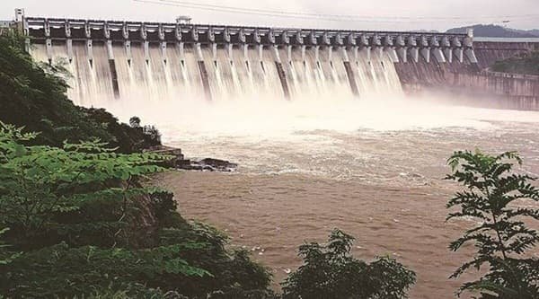
Ukai Dam Overview
| Parameter | Details |
| State | Gujarat |
| District | Tapi district |
| Official name | Ukai Water Resources Project |
| Reservoir name | Vallabh Sagar |
| River | Tapi River (also spelled Tapti) |
| Distance from Surat | Approx. 94–100 km upstream |
| Dam type | Composite — earth-cum-masonry dam |
| Height (earthen section) | 105.156 metres (345 ft) |
| Height (masonry section) | 68.68 metres |
| Length | 4,927 metres (approx. 4.9 km) |
| Spillway gates | 22, radial, Ogee type |
| Spillway capacity | 46,269 cubic metres/second |
| Reservoir gross capacity | 7,414 MCM (261.82 TMC ft) |
| Reservoir active capacity | 6,730 MCM (237.67 TMC ft) |
| Catchment area | 62,225 sq. km |
| Reservoir surface area | 612 sq. km |
| Installed power capacity | 300 MW |
| Construction period | 1964 to 1972 |
| Rank in Gujarat | Second-largest reservoir after Sardar Sarovar |
| Left bank canal command | 1,522 sq. km |
| Right bank canal command | 2,275 sq. km |
| Notable event | 2006 Surat flood, linked to sudden dam releases |
| Best time to visit | November to February |
The River That Built Surat — and Nearly Drowned It
The Tapi River, on which Ukai Dam sits, is one of only a handful of major Indian rivers that flow west into the Arabian Sea rather than east or south. Rising in the Satpura hill ranges of Madhya Pradesh, it flows through Maharashtra before entering Gujarat, eventually passing through Surat on its way to the sea. This westward course, combined with a large catchment area, gives the Tapi a flow pattern that can swing dramatically between dry-season trickle and monsoon surge — precisely the kind of river that large storage dams are meant to tame.
Ukai Dam draws from a catchment spanning 62,225 sq. km, an area large enough that heavy rainfall anywhere across Madhya Pradesh’s or Maharashtra’s portion of the basin can translate into a rapid rise in reservoir inflow at Ukai, sometimes with only days of warning. This scale is exactly why the dam’s flood-control role carries such weight — and why failures in that role, as in 2006, carry such consequences.
From 1964 to 1972: Building Gujarat’s Second-Largest Reservoir
Construction on Ukai Dam began in 1964, and the project took eight years to complete, becoming fully operational in 1972. Built as a composite structure combining earthen embankment sections with masonry construction, the dam was designed from the outset to serve three purposes simultaneously: irrigation for South Gujarat’s agricultural belt, hydroelectric power generation, and flood control for Surat and surrounding areas downstream.
A few historical points worth noting:
- The project created Vallabh Sagar, a reservoir that remains Gujarat’s second-largest after the Sardar Sarovar Dam on the Narmada
- Its scale at the time of completion was comparable to the Bhakra Nangal Dam in terms of storage capacity, a significant benchmark for Indian dam engineering of that era
- The dam successfully managed major flood events in 1978 and 1979, establishing an early reputation for effective flood moderation — a reputation that would later be seriously tested
The Weight of a Single Monsoon: What Happened in 2006
Understanding Ukai Dam’s place in Indian infrastructure history means confronting the events of August 2006 directly. Heavy rainfall across the upper Tapi basin pushed reservoir inflows to extraordinary levels — by 7 August, inflow had crossed 8.5 lakh cusecs, and authorities were forced into an emergency release exceeding 9 lakh cusecs to prevent the dam itself from being overwhelmed.
The consequences downstream were catastrophic:
- Between 80 and 95 percent of Surat city went underwater over four days, from 7 to 10 August 2006
- Official death tolls ranged from 120 to 150, with unofficial estimates running as high as 500
- Property damage was estimated between Rs 9,500 crore and Rs 21,000 crore
- More than 2 million people were left cut off from food and drinking water for several days
Two independent inquiry committees — the People’s Committee on Gujarat Floods, chaired by a former acting Chief Justice of the Gujarat High Court, and the Surat Citizens’ Council Trust’s committee — both concluded that the disaster wasn’t purely a natural event. Their findings pointed to delayed decision-making around water release: reservoir levels had already crossed the prescribed rule level days before the emergency release, yet officials hesitated to begin controlled discharge earlier, reportedly weighing storage targets against flood risk until the situation became unmanageable.
This wasn’t even Surat’s first Ukai-linked flood. A 1998 flood, also caused by water release from the dam, had already submerged over 30 percent of the city — a warning sign that, in hindsight, went largely unheeded before 2006.
Engineering Specifications: A Dam Built in Two Materials
Ukai Dam’s composite design reflects the geological realities of the site. Its main structure combines:
- An earthen embankment section rising 105.156 metres (345 ft), among the taller earth-dam sections in western India
- A masonry section reaching 68.68 metres, forming the more rigid core of the structure
- A total combined length of 4,927 metres across the Tapi valley
- A spillway fitted with 22 radial, Ogee-type gates, capable of passing up to 46,269 cubic metres of water per second during extreme flood conditions
That spillway capacity is central to the dam’s flood-control mission — and also central to why 2006 unfolded the way it did. The physical capacity to release water safely existed; what failed, according to the inquiry reports, was the timing and pace of the decision to actually use it.
What the Reservoir and Canal Network Support
Beyond flood management, Ukai Dam’s core function remains irrigation and power supply for South Gujarat. The numbers involved are substantial:
- Reservoir capacity: 7,414 MCM gross, with 6,730 MCM classified as active, usable storage
- Left bank canal: irrigates approximately 1,522 sq. km of farmland
- Right bank canal: irrigates a larger area of approximately 2,275 sq. km
- Combined irrigation footprint: recent estimates put total irrigated area at roughly 3.31 lakh hectares across multiple districts
This irrigation network has been central to transforming South Gujarat’s agricultural output since the 1970s, supporting cotton, sugarcane, and food-grain cultivation across a region that would otherwise depend heavily on an unpredictable monsoon-fed river.
Power Generation: A Steady Contributor to the Grid
Ukai Dam’s power station has an installed capacity of 300 MW, generated through conventional hydroelectric turbines operating on a hydraulic head ranging between 34 and 57 metres depending on reservoir level. Over its operational lifetime, the plant has contributed a meaningful, steady supply to Gujarat’s grid — recent reporting estimated cumulative generation of around 3,000 million units of electricity over a seven-year stretch, underscoring the dam’s ongoing role well beyond its more headline-grabbing flood-control function.
Dam Safety and Operations Since 2006
The 2006 disaster fundamentally changed how Ukai Dam’s operations are scrutinised. In the years since, the emphasis has shifted toward earlier, more incremental water releases during rising inflow periods rather than delayed, large-scale emergency discharges. Key operational lessons drawn from post-flood analysis include:
- Earlier and more transparent communication between dam authorities and Surat’s municipal and district administration during rising reservoir levels
- Greater reliance on real-time inflow forecasting rather than adherence to rigid “rule level” targets that delayed action in 2006
- Continued monitoring by bodies including the National Dam Safety Authority, which has highlighted Ukai’s scale and ongoing operational importance in recent public communications
Even so, Surat’s relationship with the Tapi River during monsoon season remains watchful rather than fully settled — a legacy of 2006 that shapes civic anxiety every time upstream rainfall intensifies.
Visiting Ukai Dam
For travellers interested in seeing the dam itself:
- The site lies in Tapi district, roughly 94–100 km from Surat, making it accessible as a day trip
- The nearby Vajpur Fort, a historic structure predating the dam, adds a heritage dimension to a visit focused primarily on the reservoir and dam structure
- Post-monsoon months, from November through February, offer the best combination of full reservoir views and pleasant weather
- Visiting during peak monsoon discharge periods should be approached with caution and awareness of current release schedules, given the site’s history
FAQs
Q. Was the 2006 Surat flood caused by the dam itself failing, or by decisions about water release?
The flood resulted from a sudden, large-scale water release during an extreme rainfall event rather than a structural failure of the dam itself, with independent inquiry committees attributing much of the disaster’s severity to delayed decision-making on when to begin releasing water.
Q. Has dam operation changed since the 2006 flood to prevent a repeat?
Yes — post-flood reviews pushed for earlier and more gradual water releases during rising inflow periods, along with improved coordination with Surat’s local administration, rather than waiting for reservoir levels to approach critical thresholds before acting.
Q. Why is Ukai Dam considered vital to South Gujarat’s agriculture, not just flood control?
Its canal network irrigates over 3.31 lakh hectares across multiple districts through separate left and right bank canal systems, making it a primary water source for the region’s cotton, sugarcane, and food-grain cultivation.
Q. Is it safe to visit areas near the Tapi River downstream of Ukai Dam during monsoon season?
Caution is advisable during periods of heavy upstream rainfall, since the dam’s flood-control releases can raise downstream water levels quickly, and checking current reservoir status or local advisories before visiting is a sensible precaution.